
Carte topographique Lecks
Carte interactive
Cliquez sur la carte pour afficher l’altitude.
À propos de cette carte
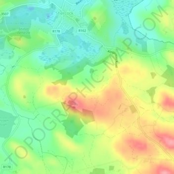
Nom : Carte topographique Lecks, altitude, relief.
Altitude moyenne : 128 m
Altitude minimum : 85 m
Altitude maximum : 187 m
Autres cartes topographiques
Cliquez sur une carte pour visualiser sa topographie, son altitude et son relief.
Bellananagh
Bellananagh, Bellananagh ED, Ballyjamesduff Municipal District, County Cavan, H12 K727, Ireland
Altitude moyenne : 94 m
Red Island
Ireland > County Cavan > Carrickclevan
Red Island, Carrickclevan, Drumcarban ED, Ballyjamesduff Municipal District, County Cavan, Ulster, Ireland
Altitude moyenne : 76 m
Cock Island
Cock Island, Munterconnaught ED, Ballyjamesduff Municipal District, County Cavan, Ireland
Altitude moyenne : 90 m
Virgina
Virgina, Virginia ED, Ballyjamesduff Municipal District, County Cavan, Ulster, Ireland
Altitude moyenne : 101 m