
Carte topographique Dolný Kubín
Carte interactive
Cliquez sur la carte pour afficher l’altitude.
À propos de cette carte
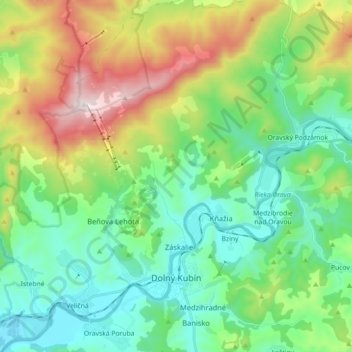
Nom : Carte topographique Dolný Kubín, altitude, relief.
Altitude moyenne : 726 m
Altitude minimum : 443 m
Altitude maximum : 1 384 m
Dolný Kubín lies at an altitude of 468 metres (1,535 ft) above sea level and covers an area of 55.055 square kilometres (21.3 sq mi). It is located in northern Slovakia on the Orava River, between the Lesser Fatra, Oravská Magura and Chočské vrchy mountains. It is located around 15 km (9.32 mi) from Ružomberok, 45 km (27.96 mi) from the Polish border and 270 km (167.77 mi) from Bratislava. The town is composed of the following boroughs: Banisko, Beňova Lehota, Brezovec, Kňažia, Malý Bysterec, Medzihradné, Mokraď, Srňacie, Staré mesto, Veľký Bysterec and Záskalie. The city limits also encompass the settlement of Jelšava.