
Carte topographique Fort MacKay
Carte interactive
Cliquez sur la carte pour afficher l’altitude.
À propos de cette carte
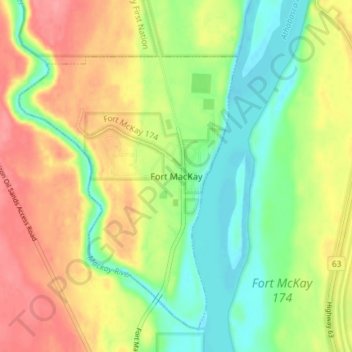
Nom : Carte topographique Fort MacKay, altitude, relief.
Lieu : Fort MacKay, Wood Buffalo, Alberta, T0P 1C0, Canada (57.16257 -111.65784 57.20257 -111.61784)
Altitude moyenne : 265 m
Altitude minimum : 228 m
Altitude maximum : 306 m
Fort McKay (/məˈkaɪ/ mə-KY) or Fort MacKay is a community in northeast Alberta, Canada that is located at the confluence of the Athabasca and MacKay rivers. It is approximately 54 km (34 mi) north of Fort McMurray via Highway 63 and Fort McKay Road. The community has an elevation of 260 m (850 ft).