
Faire un don
Équipez-vous pour votre prochaine aventure :
En tant que Partenaire Amazon, ce site perçoit une commission sur les achats éligibles sans surcoût pour vous.
Carte topographique Montecalvo Irpino
Cliquez sur la carte pour afficher l’altitude.
Faire un don
Équipez-vous pour votre prochaine aventure :
En tant que Partenaire Amazon, ce site perçoit une commission sur les achats éligibles sans surcoût pour vous.
Montecalvo Irpino
Montecalvo Irpino is located in the northern sector of the province of Avellino, on the border with Benevento. The municipality, built at an elevation of 2,044 ft (623 m) MSL, upstream of the confluence between the Miscano stream and the Ufita River, is part of the mountain community of Ufita. Its land is mostly clayey and tuffaceous, and is mainly mountainous. The municipal countryside covers an area of 20.67 sq mi (53.50 km2), with an altitude ranging from 151 to 700 m above sea level, with an excursion of 549 m.
Faire un don
Équipez-vous pour votre prochaine aventure :
En tant que Partenaire Amazon, ce site perçoit une commission sur les achats éligibles sans surcoût pour vous.
À propos de cette carte
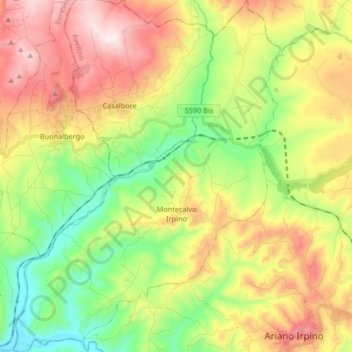
Nom : Carte topographique Montecalvo Irpino, altitude, relief.
Lieu : Montecalvo Irpino, Avellino, Campania, Italy (41.14681 14.95692 41.27093 15.08208)
Altitude moyenne : 497 m
Altitude minimum : 165 m
Altitude maximum : 936 m
Faire un don
Équipez-vous pour votre prochaine aventure :
En tant que Partenaire Amazon, ce site perçoit une commission sur les achats éligibles sans surcoût pour vous.
Autres cartes topographiques
Cliquez sur une carte pour visualiser sa topographie, son altitude et son relief.
Faire un don
Équipez-vous pour votre prochaine aventure :
En tant que Partenaire Amazon, ce site perçoit une commission sur les achats éligibles sans surcoût pour vous.