
Carte topographique Burao
Carte interactive
Cliquez sur la carte pour afficher l’altitude.
À propos de cette carte
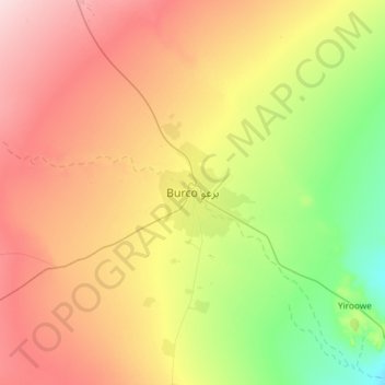
Nom : Carte topographique Burao, altitude, relief.
Lieu : Burao, Burao District, Togdheer, Somaliland, Somalia (9.36776 45.37811 9.68776 45.69811)
Altitude moyenne : 1 051 m
Altitude minimum : 945 m
Altitude maximum : 1 171 m
Weather in Burao, much like other inland towns in Somaliland, is very warm to hot and dry year-round. The city has a hot arid climate (Köppen BWh) in common with most of Somalia, although Burao's weather is moderated by altitude. The average daytime temperatures during the summer months of June and August can rise to 31 °C or 87.8 °F, with a low of 20 °C or 68 °F at night. The weather is cooler the rest of the year, averaging 27 °C or 80.6 °F during the day and 13 °C or 55.4 °F at nighttime. The city's limited rainfall of 222 millimetres or 9 inches usually comes with two peaks during April–May and October–November.
Autres cartes topographiques
Cliquez sur une carte pour visualiser sa topographie, son altitude et son relief.
Togdheer
Somalia > Togdheer > Burao District
Togdheer, Burao District, Togdheer, Somaliland, Somalia
Altitude moyenne : 930 m