
Faire un don
Équipez-vous pour votre prochaine aventure :
En tant que Partenaire Amazon, ce site perçoit une commission sur les achats éligibles sans surcoût pour vous.
Carte topographique Brindisi
Cliquez sur la carte pour afficher l’altitude.
Faire un don
Équipez-vous pour votre prochaine aventure :
En tant que Partenaire Amazon, ce site perçoit une commission sur les achats éligibles sans surcoût pour vous.
Brindisi
Brindisi experiences a Mediterranean climate (Köppen: Csa). Summers are hot and dry with abundant sunshine. Summer heat indexes can be regularly over 30 °C (86 °F) and occasionally as high as 37 °C during July and August. Winters are mild with moderate rainfall. Brindisi and the mostly topographically flat Salento peninsula is subject to light winds during the majority of the year. The two main winds in Salento are the Maestral and the Scirocco. The northerly Maestral wind from the Adriatic sea is cooling, moderating summer heat and increasing winter wind chill. The southerly Scirocco wind from the Sahara, brings higher temperatures and humidity to Salento. During spring and autumn, Sirocco winds can bring thunderstorms, occasionally dropping red sand from the Sahara in the region. Snow is rare in Brindisi but occurred during the January 2017 cold spell which brought snow and ice to much of southern Italy.
Faire un don
Équipez-vous pour votre prochaine aventure :
En tant que Partenaire Amazon, ce site perçoit une commission sur les achats éligibles sans surcoût pour vous.
À propos de cette carte
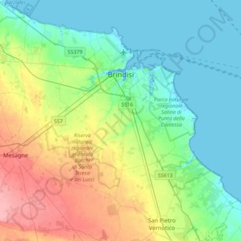
Nom : Carte topographique Brindisi, altitude, relief.
Lieu : Brindisi, Apulia, Italy (40.47842 17.73166 40.70848 18.04528)
Altitude moyenne : 27 m
Altitude minimum : -3 m
Altitude maximum : 90 m
Faire un don
Équipez-vous pour votre prochaine aventure :
En tant que Partenaire Amazon, ce site perçoit une commission sur les achats éligibles sans surcoût pour vous.
Autres cartes topographiques
Cliquez sur une carte pour visualiser sa topographie, son altitude et son relief.