
Carte topographique Village of Black River
Carte interactive
Cliquez sur la carte pour afficher l’altitude.
À propos de cette carte
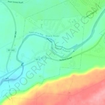
Nom : Carte topographique Village of Black River, altitude, relief.
Altitude moyenne : 193 m
Altitude minimum : 153 m
Altitude maximum : 270 m
Autres cartes topographiques
Cliquez sur une carte pour visualiser sa topographie, son altitude et son relief.
City of Watertown
United States > New York > Jefferson County
City of Watertown, Jefferson County, New York, 13601, United States
Altitude moyenne : 150 m
Village of Adams
United States > New York > Jefferson County > Town of Adams
Village of Adams, Town of Adams, Jefferson County, New York, United States
Altitude moyenne : 189 m
Village of Alexandria Bay
United States > New York > Jefferson County
Village of Alexandria Bay, Town of Alexandria, Jefferson County, New York, United States
Altitude moyenne : 80 m
Thousand Islands
United States > New York > Jefferson County
Thousand Islands, Town of Orleans, Jefferson County, New York, 13640, United States
Altitude moyenne : 111 m
Fort Drum
United States > New York > Jefferson County
Fort Drum, Town of Le Ray, Jefferson County, New York, United States
Altitude moyenne : 174 m