
Carte topographique Diablo Lake
Carte interactive
Cliquez sur la carte pour afficher l’altitude.
À propos de cette carte
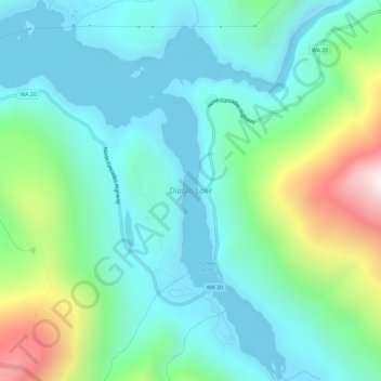
Nom : Carte topographique Diablo Lake, altitude, relief.
Lieu : Diablo Lake, Whatcom County, Washington, United States (48.68160 -121.13257 48.72013 -121.08459)
Altitude moyenne : 643 m
Altitude minimum : 362 m
Altitude maximum : 1 538 m
Diablo Lake is a reservoir in the North Cascade mountains of northern Washington state, United States. Created by Diablo Dam, the lake is located between Ross Lake and Gorge Lake on the Skagit River at an elevation of 1,201 feet (366 m) above sea level. Diablo Lake is part of the Skagit River Hydroelectric Project and managed by Seattle City Light.
Autres cartes topographiques
Cliquez sur une carte pour visualiser sa topographie, son altitude et son relief.
Lummi Island
United States > Washington > Whatcom County
Lummi Island, Whatcom County, Washington, United States
Altitude moyenne : 24 m
Ross Lake
United States > Washington > Whatcom County
Ross Lake, Whatcom County, Washington, United States
Altitude moyenne : 1 314 m
Bellingham
United States > Washington > Whatcom County
Bellingham, Whatcom County, Washington, United States
Altitude moyenne : 89 m
Hampton
United States > Washington > Whatcom County
Hampton, Whatcom County, Washington, 98276, United States
Altitude moyenne : 24 m
Custer
United States > Washington > Whatcom County
Custer, Whatcom County, Washington, 98240, United States
Altitude moyenne : 20 m
Balford
United States > Washington > Whatcom County
Balford, Whatcom County, Washington, 98266, United States
Altitude moyenne : 342 m
Acme
United States > Washington > Whatcom County
Acme, Whatcom County, Washington, 98220, United States
Altitude moyenne : 420 m
Birch Bay
United States > Washington > Whatcom County
Birch Bay, Whatcom County, Washington, United States
Altitude moyenne : 21 m
Point Roberts
United States > Washington > Whatcom County > Point Roberts
Point Roberts, Whatcom County, Washington, 98281, United States
Altitude moyenne : 9 m
Ferndale
United States > Washington > Whatcom County > Ferndale
Ferndale, Whatcom County, Washington, 98248, United States
Altitude moyenne : 29 m
Sudden Valley
United States > Washington > Whatcom County
Sudden Valley, Whatcom County, Washington, 98228, United States
Altitude moyenne : 239 m
Ferndale
United States > Washington > Whatcom County
Ferndale, Whatcom County, Washington, United States
Altitude moyenne : 29 m
Bellingham
United States > Washington > Whatcom County > Bellingham
Bellingham, Whatcom County, Washington, 98225-3243, United States
Altitude moyenne : 129 m
Blaine
United States > Washington > Whatcom County > Blaine
Blaine, Whatcom County, Washington, United States
Altitude moyenne : 23 m