
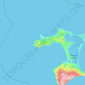
Carte topographique Chatham Island
Carte interactive
Cliquez sur la carte pour afficher l’altitude.
À propos de cette carte
Nom : Carte topographique Chatham Island, altitude, relief.
Lieu : Chatham Island, Chatham Islands, Neuseeland (-44.12555 -177.11285 -43.48555 -176.47285)
Altitude moyenne : 12 m
Altitude minimum : -1 m
Altitude maximum : 295 m
Autres cartes topographiques
Cliquez sur une carte pour visualiser sa topographie, son altitude et son relief.
Linwood-Central-Heathcote Community
Neuseeland > Canterbury > Christchurch City
Linwood-Central-Heathcote Community, Christchurch City, Canterbury, Neuseeland
Altitude moyenne : 55 m
Christchurch
Neuseeland > Canterbury > Christchurch
Christchurch, Christchurch City, Canterbury, Neuseeland
Altitude moyenne : 41 m
Queenstown
Queenstown, Queenstown-Lakes District, Otago, 9348, Neuseeland
Altitude moyenne : 596 m
Hinuera
Neuseeland > Waikato > Hinuera
Hinuera, Matamata Piako District, Waikato, Neuseeland
Altitude moyenne : 84 m
Aoraki / Mount Cook
Aoraki / Mount Cook, Mackenzie District, Canterbury, Neuseeland
Altitude moyenne : 2 920 m
Rangitoto Island
Neuseeland > Auckland > Waiheke
Rangitoto Island, Waiheke, Auckland, Neuseeland
Altitude moyenne : 30 m
Reefton
Reefton, Buller District, West Coast, 7830, Neuseeland
Altitude moyenne : 310 m
Lake Ōkataina
Neuseeland > Bay of Plenty > Ruato
Lake Ōkataina, Eastern Okataina Walkway, Ruato, Rotorua District, Bay of Plenty, Neuseeland
Altitude moyenne : 440 m
Mount Ngāuruhoe
Mount Ngāuruhoe, Ruapehu District, Manawatu-Wanganui, Neuseeland
Altitude moyenne : 1 726 m
Reporoa
Neuseeland > Waikato > Reporoa
Reporoa, Rotorua District, Waikato, Neuseeland
Altitude moyenne : 304 m
Whakatāne District
Whakatāne District, Bay of Plenty, Neuseeland
Altitude moyenne : 416 m
Lake Benmore
Lake Benmore, Falston Road, Waitaki District, Canterbury, Neuseeland
Altitude moyenne : 746 m
Mayor Island / Tuhua
Neuseeland > Bay of Plenty > Tauranga
Mayor Island / Tuhua, Tauranga, Bay of Plenty, Neuseeland
Altitude moyenne : 71 m
Rotorua District
Rotorua District, Bay of Plenty, Neuseeland
Altitude moyenne : 404 m
Monowai
Monowai, Southland District, Southland, Neuseeland
Altitude moyenne : 186 m
Nordinsel
Nordinsel, South Waikato District, Waikato, Neuseeland
Altitude moyenne : 66 m
Wellington City
Wellington City, Wellington, Neuseeland
Altitude moyenne : 80 m
Lake Karapiro
Neuseeland > Waikato > Arapuni
Lake Karapiro, Waikato River Trail, Arapuni, South Waikato District, Waikato, 3494, Neuseeland
Altitude moyenne : 174 m
Godley Glacier
Godley Glacier, Mackenzie District, Canterbury, Neuseeland
Altitude moyenne : 1 579 m
Lake Rotorangi
Lake Rotorangi, Rotorangi Road, South Taranaki District, Taranaki, Neuseeland
Altitude moyenne : 139 m