
Carte topographique Le Fay de la Lande
Carte interactive
Cliquez sur la carte pour afficher l’altitude.
À propos de cette carte
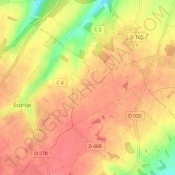
Nom : Carte topographique Le Fay de la Lande, altitude, relief.
Altitude moyenne : 258 m
Altitude minimum : 219 m
Altitude maximum : 276 m
Autres cartes topographiques
Cliquez sur une carte pour visualiser sa topographie, son altitude et son relief.
La Perrotière
France > Normandie > Orne > La Chapelle-Viel
La Perrotière, La Chapelle-Viel, Mortagne-au-Perche, Orne, Normandie, France métropolitaine, 61270, France
Altitude moyenne : 251 m