
Carte topographique Trunstadt
Carte interactive
Cliquez sur la carte pour afficher l’altitude.
À propos de cette carte
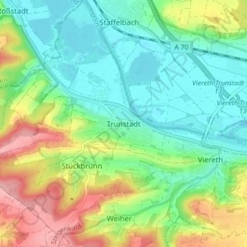
Nom : Carte topographique Trunstadt, altitude, relief.
Altitude moyenne : 274 m
Altitude minimum : 224 m
Altitude maximum : 370 m
Autres cartes topographiques
Cliquez sur une carte pour visualiser sa topographie, son altitude et son relief.
Viereth
Deutschland > Bayern > Landkreis Bamberg > Viereth-Trunstadt
Viereth, Viereth-Trunstadt, Landkreis Bamberg, Bayern, 96191, Deutschland
Altitude moyenne : 270 m