
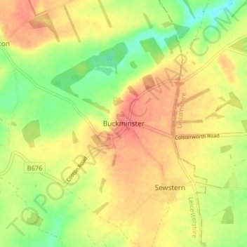
Carte topographique Buckminster
Carte interactive
Cliquez sur la carte pour afficher l’altitude.
À propos de cette carte
Nom : Carte topographique Buckminster, altitude, relief.
Altitude moyenne : 138 m
Altitude minimum : 105 m
Altitude maximum : 163 m
Autres cartes topographiques
Cliquez sur une carte pour visualiser sa topographie, son altitude et son relief.
Sproxton
United Kingdom > England > Leicestershire > Borough of Melton > Sproxton
Sproxton, Borough of Melton, Leicestershire, England, United Kingdom
Altitude moyenne : 137 m
Eye Kettleby
United Kingdom > England > Leicestershire > Borough of Melton > Melton Mowbray
Eye Kettleby, Melton Mowbray, Borough of Melton, Leicestershire, England, LE14 2TD, United Kingdom
Altitude moyenne : 95 m
Somerby
United Kingdom > England > Leicestershire > Borough of Melton
Somerby, Borough of Melton, Leicestershire, England, LE14 2QA, United Kingdom
Altitude moyenne : 169 m
Long Clawson
United Kingdom > England > Leicestershire > Borough of Melton
Long Clawson, Borough of Melton, Leicestershire, England, LE14 4NA, United Kingdom
Altitude moyenne : 78 m
Garthorpe
United Kingdom > England > Leicestershire > Borough of Melton
Garthorpe, Borough of Melton, Leicestershire, England, LE14 2SJ, United Kingdom
Altitude moyenne : 115 m
Frisby on the Wreake
United Kingdom > England > Leicestershire > Borough of Melton
Frisby on the Wreake, Borough of Melton, Leicestershire, England, LE14 2NQ, United Kingdom
Altitude moyenne : 83 m