
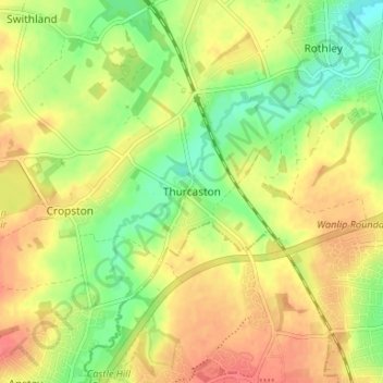
Carte topographique Thurcaston
Carte interactive
Cliquez sur la carte pour afficher l’altitude.
À propos de cette carte
Nom : Carte topographique Thurcaston, altitude, relief.
Altitude moyenne : 73 m
Altitude minimum : 45 m
Altitude maximum : 97 m
Autres cartes topographiques
Cliquez sur une carte pour visualiser sa topographie, son altitude et son relief.
Mammoth Lake
United Kingdom > England > Leicestershire > Borough of Charnwood > Thurmaston
Mammoth Lake, Thurmaston, Borough of Charnwood, Leicestershire, England, United Kingdom
Altitude moyenne : 58 m
Barkby Thorpe
United Kingdom > England > Leicestershire > Borough of Charnwood
Barkby Thorpe, Borough of Charnwood, Leicestershire, England, United Kingdom
Altitude moyenne : 89 m
Charnwood Forest Canal (Disused)
United Kingdom > England > Leicestershire > Borough of Charnwood > Nanpantan
Charnwood Forest Canal (Disused), Nanpantan, Borough of Charnwood, Leicestershire, England, LE11 3YA, United Kingdom
Altitude moyenne : 98 m
Anstey
United Kingdom > England > Leicestershire > Borough of Charnwood
Anstey, Borough of Charnwood, Leicestershire, England, United Kingdom
Altitude moyenne : 84 m
Wanlip
United Kingdom > England > Leicestershire > Borough of Charnwood
Wanlip, Borough of Charnwood, Leicestershire, England, LE7 4PH, United Kingdom
Altitude moyenne : 61 m
Ratcliffe on the Wreake
United Kingdom > England > Leicestershire > Borough of Charnwood
Ratcliffe on the Wreake, Borough of Charnwood, Leicestershire, England, LE7 4SN, United Kingdom
Altitude moyenne : 68 m
Seagrave
United Kingdom > England > Leicestershire > Borough of Charnwood
Seagrave, Borough of Charnwood, Leicestershire, England, LE12 7NL, United Kingdom
Altitude moyenne : 92 m