
Carte topographique Hohenburg
Carte interactive
Cliquez sur la carte pour afficher l’altitude.
À propos de cette carte
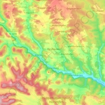
Nom : Carte topographique Hohenburg, altitude, relief.
Lieu : Hohenburg, Landkreis Amberg-Sulzbach, Bavaria, 92277, Germany (49.27916 11.72177 49.34238 11.88455)
Altitude moyenne : 472 m
Altitude minimum : 360 m
Altitude maximum : 602 m
Autres cartes topographiques
Cliquez sur une carte pour visualiser sa topographie, son altitude et son relief.
Bergstein
Germany > Bavaria > Landkreis Amberg-Sulzbach > Illschwang
Bergstein, Illschwang, Illschwang (VGem), Landkreis Amberg-Sulzbach, Bavaria, 92278, Germany
Altitude moyenne : 548 m
Vilseck
Germany > Bavaria > Landkreis Amberg-Sulzbach
Vilseck, Landkreis Amberg-Sulzbach, Bavaria, 92249, Germany
Altitude moyenne : 443 m
Schmidmühlen
Germany > Bavaria > Landkreis Amberg-Sulzbach
Schmidmühlen, Landkreis Amberg-Sulzbach, Bavaria, 92287, Germany
Altitude moyenne : 431 m