
Carte topographique Stara Wieś
Carte interactive
Cliquez sur la carte pour afficher l’altitude.
À propos de cette carte
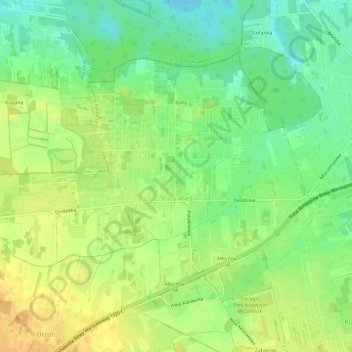
Nom : Carte topographique Stara Wieś, altitude, relief.
Altitude moyenne : 121 m
Altitude minimum : 105 m
Altitude maximum : 136 m
Autres cartes topographiques
Cliquez sur une carte pour visualiser sa topographie, son altitude et son relief.
Nadarzyn
Poland > Masovian Voivodeship > Pruszków County
Nadarzyn, gmina Nadarzyn, Pruszków County, Masovian Voivodeship, 05-830, Poland
Altitude moyenne : 112 m
Rybie
Poland > Masovian Voivodeship > Pruszków County > Rybie
Rybie, gmina Raszyn, Pruszków County, Masovian Voivodeship, Poland
Altitude moyenne : 106 m
Pruszków
Poland > Masovian Voivodeship > Pruszków County > Pruszków
Pruszków, gmina Ożarów Mazowiecki, Pruszków County, Masovian Voivodeship, Poland
Altitude moyenne : 99 m