
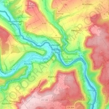
Carte topographique Wallendorf
Carte interactive
Cliquez sur la carte pour afficher l’altitude.
À propos de cette carte
Nom : Carte topographique Wallendorf, altitude, relief.
Altitude moyenne : 296 m
Altitude minimum : 171 m
Altitude maximum : 414 m
Autres cartes topographiques
Cliquez sur une carte pour visualiser sa topographie, son altitude et son relief.
Hüttingen an der Kyll
Deutschland > Rheinland-Pfalz > Eifelkreis Bitburg-Prüm
Hüttingen an der Kyll, Bitburger Land, Eifelkreis Bitburg-Prüm, Rheinland-Pfalz, Deutschland
Altitude moyenne : 296 m
Meckel
Deutschland > Rheinland-Pfalz > Eifelkreis Bitburg-Prüm
Meckel, Bitburger Land, Eifelkreis Bitburg-Prüm, Rheinland-Pfalz, Deutschland
Altitude moyenne : 337 m
Daleiden
Deutschland > Rheinland-Pfalz > Eifelkreis Bitburg-Prüm
Daleiden, Arzfeld, Eifelkreis Bitburg-Prüm, Rheinland-Pfalz, 54689, Deutschland
Altitude moyenne : 431 m
Ferschweiler
Deutschland > Rheinland-Pfalz > Eifelkreis Bitburg-Prüm
Ferschweiler, Südeifel, Eifelkreis Bitburg-Prüm, Rheinland-Pfalz, Deutschland
Altitude moyenne : 346 m
Manderscheid
Deutschland > Rheinland-Pfalz > Eifelkreis Bitburg-Prüm
Manderscheid, Arzfeld, Eifelkreis Bitburg-Prüm, Rheinland-Pfalz, Deutschland
Altitude moyenne : 433 m
Rodershausen
Deutschland > Rheinland-Pfalz > Eifelkreis Bitburg-Prüm > Rodershausen
Rodershausen, Südeifel, Eifelkreis Bitburg-Prüm, Rheinland-Pfalz, Deutschland
Altitude moyenne : 443 m
Irrel
Deutschland > Rheinland-Pfalz > Eifelkreis Bitburg-Prüm
Irrel, Südeifel, Eifelkreis Bitburg-Prüm, Rheinland-Pfalz, 54666, Deutschland
Altitude moyenne : 259 m