
Carte topographique Driesprong
Carte interactive
Cliquez sur la carte pour afficher l’altitude.
À propos de cette carte
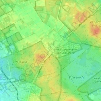
Nom : Carte topographique Driesprong, altitude, relief.
Lieu : Driesprong, Ede, Gelderland, Nederland, 6718 TP, Nederland (52.04667 5.66936 52.08667 5.70936)
Altitude moyenne : 32 m
Altitude minimum : 16 m
Altitude maximum : 51 m
Autres cartes topographiques
Cliquez sur une carte pour visualiser sa topographie, son altitude et son relief.
Edese Bos - Oost
Nederland > Gelderland > Ede
Edese Bos - Oost, Ede, Gelderland, Nederland, 6718 ZZ, Nederland
Altitude moyenne : 34 m
Vlinderdas (Noord Ginkel)
Nederland > Gelderland > Ede
Vlinderdas (Noord Ginkel), Ede, Gelderland, Nederland, 6718SL, Nederland
Altitude moyenne : 27 m
Noord Ginkel
Nederland > Gelderland > Ede
Noord Ginkel, Groot Ginkelseweg, Ede, Gelderland, Nederland, 6718 SL, Nederland
Altitude moyenne : 29 m