
Carte topographique Gniew
Carte interactive
Cliquez sur la carte pour afficher l’altitude.
À propos de cette carte
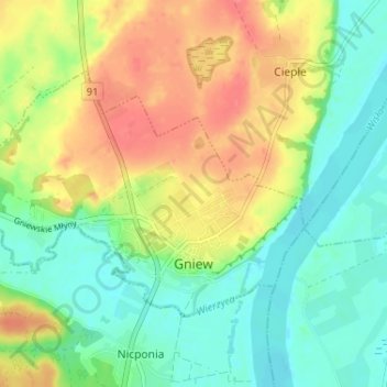
Nom : Carte topographique Gniew, altitude, relief.
Altitude moyenne : 33 m
Altitude minimum : 6 m
Altitude maximum : 70 m
Autres cartes topographiques
Cliquez sur une carte pour visualiser sa topographie, son altitude et son relief.
Tczew
Poland > Pomeranian Voivodeship > Tczew County
Tczew, Tczew County, Pomeranian Voivodeship, 83-110, Poland
Altitude moyenne : 16 m
Opalenie
Poland > Pomeranian Voivodeship > Tczew County
Opalenie, gmina Gniew, Tczew County, Pomeranian Voivodeship, 83-136, Poland
Altitude moyenne : 35 m
Turze
Poland > Pomeranian Voivodeship > Tczew County
Turze, gmina Tczew, Tczew County, Pomeranian Voivodeship, Poland
Altitude moyenne : 73 m
Tczew
Poland > Pomeranian Voivodeship > Tczew County > Tczew
Tczew, Tczew County, Pomeranian Voivodeship, 83-110, Poland
Altitude moyenne : 21 m