
Carte topographique Perinthalmanna
Carte interactive
Cliquez sur la carte pour afficher l’altitude.
À propos de cette carte
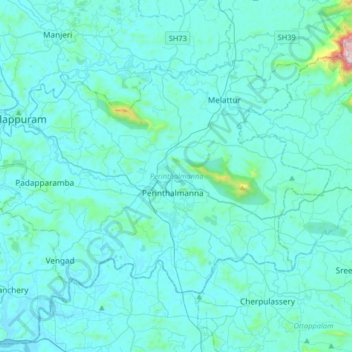
Nom : Carte topographique Perinthalmanna, altitude, relief.
Lieu : Perinthalmanna, Malappuram District, Kerala, India (10.88491 76.04708 11.09650 76.37241)
Altitude moyenne : 76 m
Altitude minimum : 3 m
Altitude maximum : 1 153 m
Autres cartes topographiques
Cliquez sur une carte pour visualiser sa topographie, son altitude et son relief.
Kodanad
India > Kerala > Kunnathunad
Kodanad, Kunnathunad, Ernakulam District, Kerala, 683544, India
Altitude moyenne : 19 m
Nedumkunnam
India > Kerala > Changanassery
Nedumkunnam, Changanassery, Kottayam District, Kerala, 686542, India
Altitude moyenne : 67 m