
Carte topographique College Park
Carte interactive
Cliquez sur la carte pour afficher l’altitude.
À propos de cette carte
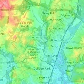
Nom : Carte topographique College Park, altitude, relief.
Altitude moyenne : 38 m
Altitude minimum : 10 m
Altitude maximum : 100 m
The Lakeland neighborhood was developed beginning in 1892 around the Baltimore and Ohio Railroad, whose Branchville and Calvert Road depots were located approximately one mile to the north and south, respectively. Lakeland was created by Edwin Newman, who improved the original 238 acres (0.96 km2) located to the west of the railroad. He also built a number of the original homes, a small town hall, and a general store. The area was originally envisioned as a resort-type community. However, due to the flood-prone, low-lying topography, the neighborhood attracted a lower-income population and became an area for African-American settlement. Around 1900, the Baltimore Gold Fish Company built five artificial lakes in the area to spawn goldfish and rare species of fish. A one-room school was built in 1903 for the African-American population; a new school was built in 1925.
Autres cartes topographiques
Cliquez sur une carte pour visualiser sa topographie, son altitude et son relief.
Auth Village
United States > Maryland > Prince George's County > Camp Springs
Auth Village, Camp Springs, Prince George's County, Maryland, 20746, United States
Altitude moyenne : 77 m
Mount Rainier
United States > Maryland > Prince George's County
Mount Rainier, Prince George's County, Maryland, 20712, United States
Altitude moyenne : 20 m
Beltsville
United States > Maryland > Prince George's County
Beltsville, Prince George's County, Maryland, 20705, United States
Altitude moyenne : 55 m
Wildercroft
United States > Maryland > Prince George's County > East Riverdale
Wildercroft, East Riverdale, Prince George's County, Maryland, 20052, United States
Altitude moyenne : 39 m
Rosaryville State Park
United States > Maryland > Prince George's County > Upper Marlboro
Rosaryville State Park, 7805, Upper Marlboro, Prince George's County, Maryland, 20735, United States
Altitude moyenne : 59 m
Hyattsville
United States > Maryland > Prince George's County
Hyattsville, Prince George's County, Maryland, 20781, United States
Altitude moyenne : 61 m
Glenn Dale
United States > Maryland > Prince George's County
Glenn Dale, Prince George's County, Maryland, 20769, United States
Altitude moyenne : 51 m
Forestville
United States > Maryland > Prince George's County
Forestville, Prince George's County, Maryland, 20747, United States
Altitude moyenne : 71 m
Cottage City
United States > Maryland > Prince George's County
Cottage City, Prince George's County, Maryland, United States
Altitude moyenne : 17 m
Camp Springs
United States > Maryland > Prince George's County
Camp Springs, Prince George's County, Maryland, 20762, United States
Altitude moyenne : 75 m
Lake Arbor
United States > Maryland > Prince George's County
Lake Arbor, Prince George's County, Maryland, United States
Altitude moyenne : 46 m
Coral Hills
United States > Maryland > Prince George's County
Coral Hills, Prince George's County, Maryland, 20743, United States
Altitude moyenne : 69 m
Croom
United States > Maryland > Prince George's County
Croom, Prince George's County, Maryland, United States
Altitude moyenne : 47 m
Fort Washington
United States > Maryland > Prince George's County
Fort Washington, Prince George's County, Maryland, 20607, United States
Altitude moyenne : 26 m
Andrews Manor
United States > Maryland > Prince George's County > Camp Springs
Andrews Manor, Camp Springs, Prince George's County, Maryland, 20762, United States
Altitude moyenne : 79 m
Berwyn Heights
United States > Maryland > Prince George's County
Berwyn Heights, Prince George's County, Maryland, United States
Altitude moyenne : 33 m
Mellwood
United States > Maryland > Prince George's County
Mellwood, Prince George's County, Maryland, 20772, United States
Altitude moyenne : 60 m
District Heights
United States > Maryland > Prince George's County
District Heights, Prince George's County, Maryland, 20747, United States
Altitude moyenne : 77 m
Phelps Corner
United States > Maryland > Prince George's County > Oxon Hill
Phelps Corner, Oxon Hill, Prince George's County, Maryland, 20745, United States
Altitude moyenne : 58 m
West Laurel
United States > Maryland > Prince George's County > West Laurel
West Laurel, Prince George's County, Maryland, United States
Altitude moyenne : 101 m
Bowie
United States > Maryland > Prince George's County
Bowie, Prince George's County, Maryland, United States
Altitude moyenne : 38 m
Eagle Harbor
United States > Maryland > Prince George's County
Eagle Harbor, Prince George's County, Maryland, United States
Altitude moyenne : 13 m
Chestnut Hills
United States > Maryland > Prince George's County > Beltsville
Chestnut Hills, Beltsville, Prince George's County, Maryland, 20705, United States
Altitude moyenne : 47 m
Laurel
United States > Maryland > Prince George's County
Laurel, Prince George's County, Maryland, 20707, United States
Altitude moyenne : 73 m
Brentwood
United States > Maryland > Prince George's County
Brentwood, Prince George's County, Maryland, 20722, United States
Altitude moyenne : 17 m
Forestville
United States > Maryland > Prince George's County > Forestville
Forestville, Prince George's County, Maryland, United States
Altitude moyenne : 73 m
Edmonston
United States > Maryland > Prince George's County
Edmonston, Prince George's County, Maryland, 20781, United States
Altitude moyenne : 21 m
The Village
United States > Maryland > Prince George's County > Brandywine
The Village, Brandywine, Prince George's County, Maryland, 20613, United States
Altitude moyenne : 68 m
White Hall
United States > Maryland > Prince George's County > Accokeek
White Hall, Accokeek, Prince George's County, Maryland, 20607, United States
Altitude moyenne : 36 m
Upper Marlboro
United States > Maryland > Prince George's County
Upper Marlboro, Prince George's County, Maryland, United States
Altitude moyenne : 22 m
Mount Rainier Community Food Forest
United States > Maryland > Prince George's County > Mount Rainier
Mount Rainier Community Food Forest, Kaywood Gardens, Mount Rainier, Prince George's County, Maryland, United States
Altitude moyenne : 23 m
Camp Springs
United States > Maryland > Prince George's County > Camp Springs
Camp Springs, Prince George's County, Maryland, 20746, United States
Altitude moyenne : 72 m
University Park
United States > Maryland > Prince George's County > University Park
University Park, Prince George's County, Maryland, United States
Altitude moyenne : 29 m
Lake Artemesia
United States > Maryland > Prince George's County > College Park
Lake Artemesia, Lakeland, College Park, Prince George's County, Maryland, United States
Altitude moyenne : 26 m
Beltsville
United States > Maryland > Prince George's County > Beltsville
Beltsville, Prince George's County, Maryland, 20705, United States
Altitude moyenne : 61 m
Lanham
United States > Maryland > Prince George's County > Glenn Dale
Lanham, Glenn Dale, Prince George's County, Maryland, 20706, United States
Altitude moyenne : 47 m
Adelphi
United States > Maryland > Prince George's County > Adelphi
Adelphi, Prince George's County, Maryland, United States
Altitude moyenne : 56 m
Leeland
United States > Maryland > Prince George's County > Leeland
Leeland, Prince George's County, Maryland, United States
Altitude moyenne : 35 m
Seabrook Acres
United States > Maryland > Prince George's County > Seabrook > Seabrook Acres
Seabrook Acres, Seabrook, Prince George's County, Maryland, 20706, United States
Altitude moyenne : 50 m
Oxon Hill
United States > Maryland > Prince George's County > Oxon Hill
Oxon Hill, Prince George's County, Maryland, 20745, United States
Altitude moyenne : 54 m
Greater Capitol Heights
United States > Maryland > Prince George's County > Maryland Park > Greater Capitol Heights
Greater Capitol Heights, Capitol Heights, Maryland Park, Prince George's County, Maryland, 20743, United States
Altitude moyenne : 59 m
Hyattsville
United States > Maryland > Prince George's County
Hyattsville, Prince George's County, Maryland, 20782, United States
Altitude moyenne : 24 m
District Heights
United States > Maryland > Prince George's County > District Heights > District Heights
District Heights, Prince George's County, Maryland, 20747, United States
Altitude moyenne : 73 m
Landover
United States > Maryland > Prince George's County > Landover
Landover, Prince George's County, Maryland, 20785, United States
Altitude moyenne : 38 m
Chillum
United States > Maryland > Prince George's County > Chillum
Chillum, Prince George's County, Maryland, United States
Altitude moyenne : 43 m
Piscataway
United States > Maryland > Prince George's County > Piscataway
Piscataway, Prince George's County, Maryland, 20607, United States
Altitude moyenne : 36 m
Brandywine
United States > Maryland > Prince George's County
Brandywine, Prince George's County, Maryland, 20613, United States
Altitude moyenne : 61 m
Aquasco
United States > Maryland > Prince George's County > Aquasco
Aquasco, Prince George's County, Maryland, 20608, United States
Altitude moyenne : 28 m
Laurel
United States > Maryland > Prince George's County > Laurel
Laurel, Prince George's County, Maryland, 20707, United States
Altitude moyenne : 82 m
Upper Marlboro
United States > Maryland > Prince George's County > Upper Marlboro > Upper Marlboro
Upper Marlboro, Prince George's County, Maryland, 20772, United States
Altitude moyenne : 27 m