
Carte topographique Przymorze Małe
Carte interactive
Cliquez sur la carte pour afficher l’altitude.
À propos de cette carte
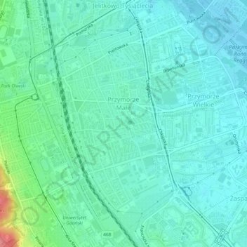
Nom : Carte topographique Przymorze Małe, altitude, relief.
Lieu : Przymorze Małe, Gdansk, Gdańsk, Pomeranian Voivodeship, Poland (54.39533 18.57031 54.41858 18.59266)
Altitude moyenne : 17 m
Altitude minimum : 0 m
Altitude maximum : 84 m
Autres cartes topographiques
Cliquez sur une carte pour visualiser sa topographie, son altitude et son relief.
Gdansk
Poland > Pomeranian Voivodeship > Gdansk
Gdansk, Pomeranian Voivodeship, Poland
Altitude moyenne : 59 m
Gdansk
Poland > Pomeranian Voivodeship > Gdansk
Gdansk, Pomeranian Voivodeship, Poland
Altitude moyenne : 46 m
Aniołki
Poland > Pomeranian Voivodeship > Gdansk
Aniołki, Gdansk, Gdańsk, Pomeranian Voivodeship, Poland
Altitude moyenne : 27 m
Zaspa-Młyniec
Poland > Pomeranian Voivodeship > Gdansk
Zaspa-Młyniec, Gdansk, Gdańsk, Pomeranian Voivodeship, Poland
Altitude moyenne : 17 m