
Carte topographique Mosnang
Carte interactive
Cliquez sur la carte pour afficher l’altitude.
À propos de cette carte
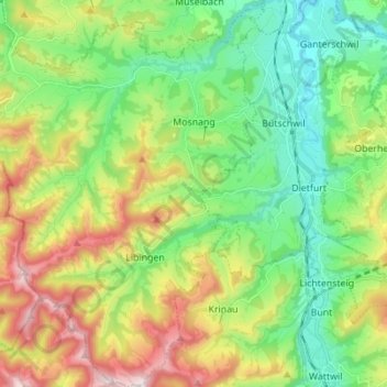
Nom : Carte topographique Mosnang, altitude, relief.
Lieu : Mosnang, Wahlkreis Toggenburg, Sankt Gallen, Zwitserland (47.29800 8.94352 47.39157 9.06565)
Altitude moyenne : 816 m
Altitude minimum : 553 m
Altitude maximum : 1 304 m
Autres cartes topographiques
Cliquez sur une carte pour visualiser sa topographie, son altitude et son relief.
Mühlrüti
Zwitserland > Sankt Gallen > Wahlkreis Toggenburg > Mosnang
Mühlrüti, Mosnang, Wahlkreis Toggenburg, Sankt Gallen, 9613, Zwitserland
Altitude moyenne : 829 m
Ebnat-Kappel
Zwitserland > Sankt Gallen > Wahlkreis Toggenburg > Ebnat-Kappel
Ebnat-Kappel, Wahlkreis Toggenburg, Sankt Gallen, 9642, Zwitserland
Altitude moyenne : 1 012 m
Wattwil
Zwitserland > Sankt Gallen > Wahlkreis Toggenburg > Wattwil
Wattwil, Wahlkreis Toggenburg, Sankt Gallen, Zwitserland
Altitude moyenne : 858 m
Wildhaus
Zwitserland > Sankt Gallen > Wahlkreis Toggenburg > Wildhaus-Alt St. Johann > Wildhaus
Wildhaus, Wildhaus-Alt St. Johann, Wahlkreis Toggenburg, Sankt Gallen, 9658, Zwitserland
Altitude moyenne : 1 244 m