
Carte topographique Bude
Carte interactive
Cliquez sur la carte pour afficher l’altitude.
Bude
Its earlier importance was as a harbour, and then a source of sea sand useful for improving the inland soil. This was transported on the Bude Canal. The Victorians favoured it as a seaside resort. With new rail links, it became a popular seaside destination in the 20th century. Bradshaw's Guide of 1866, Section 2, described Bude as: "a small port and picturesque village in the north-eastern extremity of Cornwall". It described the town as having the dignity of a fashionable marine resort with excellent facilities for bathers. The harbour bed consists of fine bright yellow sand consisting of small shells. "The sea view is of a striking, bold and sublime description – the rocks rising on every side to lofty broken elevations". It also describes Bude as a romantic retreat.
À propos de cette carte
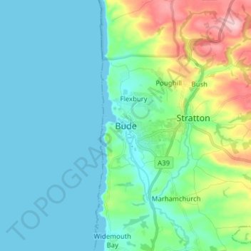
Nom : Carte topographique Bude, altitude, relief.
Lieu : Bude, Cornwall, England, EX23 8LD, United Kingdom (50.78853 -4.58694 50.86853 -4.50694)
Altitude moyenne : 39 m
Altitude minimum : 0 m
Altitude maximum : 181 m
Autres cartes topographiques
Cliquez sur une carte pour visualiser sa topographie, son altitude et son relief.