
Carte topographique Patan
Carte interactive
Cliquez sur la carte pour afficher l’altitude.
À propos de cette carte
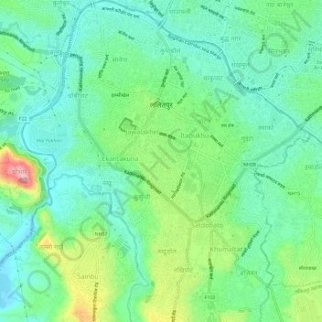
Nom : Carte topographique Patan, altitude, relief.
Altitude moyenne : 1 312 m
Altitude minimum : 1 263 m
Altitude maximum : 1 431 m
Lalitpur Metropolitan City (Sanskrit: पाटन Pāṭana, Nepal bhasa. 𑐫𑐮 Yela, ) is a Metropolitan city and fourth most populous city of Nepal with 299,843 inhabitants living in 49,044 households per 2021 cencus. It is located in the south-central part of Kathmandu Valley, a large valley in the high plateaus in central Nepal, at an altitude of 1,400 metres (4,600 feet).
Autres cartes topographiques
Cliquez sur une carte pour visualiser sa topographie, son altitude et son relief.