
Carte topographique Cuenca
Carte interactive
Cliquez sur la carte pour afficher l’altitude.
À propos de cette carte
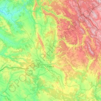
Nom : Carte topographique Cuenca, altitude, relief.
Lieu : Cuenca, Castile-La Mancha, Spain (39.82644 -2.35502 40.52300 -1.69724)
Altitude moyenne : 1 124 m
Altitude minimum : 689 m
Altitude maximum : 1 915 m
The climate of Cuenca is the typical hot-summer Mediterranean climate of Spain's "Meseta" (inner plateau). Winters are relatively cold, but summers are quite hot during the day with occasional cool nights. Spring and autumn seasons are short, with pleasant temperatures during the day but with rather cold nights due to its altitude from 956 m (3,136 ft) above sea level up to 1,000 m (3,281 ft) in the old town.
Autres cartes topographiques
Cliquez sur une carte pour visualiser sa topographie, son altitude et son relief.
Tomelloso
Spain > Castile-La Mancha > Tomelloso
Tomelloso, La Mancha, Ciudad Real, Castile-La Mancha, 13700, Spain
Altitude moyenne : 665 m
La Solana
Spain > Castile-La Mancha > La Solana
La Solana, La Mancha, Ciudad Real, Castile-La Mancha, Spain
Altitude moyenne : 736 m
Tagus
Tagus, Toledo, Castile-La Mancha, 28300, Spain
Altitude moyenne : 622 m
Iberian Peninsula
Spain > Castile-La Mancha > El Carpio de Tajo
Iberian Peninsula, Camino Natural del Tajo - GR 113, El Carpio de Tajo, Toledo, Castile-La Mancha, Spain
Altitude moyenne : 351 m