
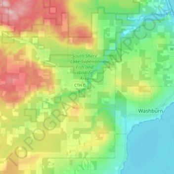
Carte topographique Sioux River
Carte interactive
Cliquez sur la carte pour afficher l’altitude.
À propos de cette carte
Nom : Carte topographique Sioux River, altitude, relief.
Altitude moyenne : 267 m
Altitude minimum : 178 m
Altitude maximum : 424 m
Autres cartes topographiques
Cliquez sur une carte pour visualiser sa topographie, son altitude et son relief.
Washburn
United States > Wisconsin > Bayfield County
Washburn, Bayfield County, Wisconsin, United States
Altitude moyenne : 213 m
Grand View
United States > Wisconsin > Bayfield County
Grand View, Town of Grandview, Bayfield County, Wisconsin, 54839, United States
Altitude moyenne : 314 m
Barksdale
United States > Wisconsin > Bayfield County
Barksdale, Town of Barksdale, Bayfield County, Wisconsin, 54806, United States
Altitude moyenne : 197 m
Drummond
United States > Wisconsin > Bayfield County
Drummond, Town of Drummond, Bayfield County, Wisconsin, United States
Altitude moyenne : 402 m
Cornucopia
United States > Wisconsin > Bayfield County
Cornucopia, Town of Bell, Bayfield County, Wisconsin, 54827, United States
Altitude moyenne : 212 m
Lund Lake
United States > Wisconsin > Bayfield County
Lund Lake, Town of Drummond, Bayfield County, Wisconsin, United States
Altitude moyenne : 367 m
Port Wing
United States > Wisconsin > Bayfield County
Port Wing, Town of Port Wing, Bayfield County, Wisconsin, 54865, United States
Altitude moyenne : 204 m
Stewart Lake
United States > Wisconsin > Bayfield County
Stewart Lake, Town of Drummond, Bayfield County, Wisconsin, United States
Altitude moyenne : 443 m
Mason
United States > Wisconsin > Bayfield County
Mason, Bayfield County, Wisconsin, United States
Altitude moyenne : 293 m
Devils Lake
United States > Wisconsin > Bayfield County
Devils Lake, Town of Barnes, Bayfield County, Wisconsin, United States
Altitude moyenne : 361 m
Bullhead Lake
United States > Wisconsin > Bayfield County
Bullhead Lake, Town of Grandview, Bayfield County, Wisconsin, United States
Altitude moyenne : 451 m
Boreal Forest
United States > Wisconsin > Bayfield County
Boreal Forest, Town of Port Wing, Bayfield County, Wisconsin, 54865, United States
Altitude moyenne : 185 m
Town of Washburn
United States > Wisconsin > Bayfield County
Town of Washburn, Bayfield County, Wisconsin, United States
Altitude moyenne : 332 m
Town of Bayfield
United States > Wisconsin > Bayfield County
Town of Bayfield, Bayfield County, Wisconsin, 54814, United States
Altitude moyenne : 244 m
Bayfield
United States > Wisconsin > Bayfield County
Bayfield, Bayfield County, Wisconsin, United States
Altitude moyenne : 245 m
Delta
United States > Wisconsin > Bayfield County
Delta, Town of Delta, Bayfield County, Wisconsin, United States
Altitude moyenne : 335 m
Town of Orienta
United States > Wisconsin > Bayfield County
Town of Orienta, Bayfield County, Wisconsin, United States
Altitude moyenne : 227 m
Town of Clover
United States > Wisconsin > Bayfield County
Town of Clover, Bayfield County, Wisconsin, 54844, United States
Altitude moyenne : 274 m
Herbster
United States > Wisconsin > Bayfield County
Herbster, Town of Clover, Bayfield County, Wisconsin, 54844, United States
Altitude moyenne : 196 m
Iron River
United States > Wisconsin > Bayfield County
Iron River, Town of Oulu, Bayfield County, Wisconsin, United States
Altitude moyenne : 289 m
Cable
United States > Wisconsin > Bayfield County
Cable, Town of Cable, Bayfield County, Wisconsin, United States
Altitude moyenne : 418 m