
Faire un don
Équipez-vous pour votre prochaine aventure :
En tant que Partenaire Amazon, ce site perçoit une commission sur les achats éligibles sans surcoût pour vous.
Carte topographique Kakamega County
Cliquez sur la carte pour afficher l’altitude.
Faire un don
Équipez-vous pour votre prochaine aventure :
En tant que Partenaire Amazon, ce site perçoit une commission sur les achats éligibles sans surcoût pour vous.
Kakamega County
Kakamega County has an altitude ranging from 1,240 metres to 2,000 metres above sea level. The southern part of the county is hilly and made of granites which raises it 1950m above sea level. The Nandi Escarpment is a key feature on the eastern border of the county with steep cliffs rising from 1700m to 2000m. The county is also endowed with a number of hills like Misango, Imanga, Eregi, Butieri, Sikhokhochole, Mawe Tatu, Lirhanda, Kiming’ini hills among others.
Faire un don
Équipez-vous pour votre prochaine aventure :
En tant que Partenaire Amazon, ce site perçoit une commission sur les achats éligibles sans surcoût pour vous.
À propos de cette carte
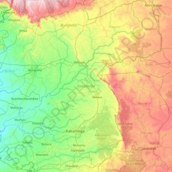
Nom : Carte topographique Kakamega County, altitude, relief.
Lieu : Kakamega County, Western, Kenya (0.08911 34.34632 0.90044 35.15610)
Altitude moyenne : 1 660 m
Altitude minimum : 1 229 m
Altitude maximum : 2 508 m
Faire un don
Équipez-vous pour votre prochaine aventure :
En tant que Partenaire Amazon, ce site perçoit une commission sur les achats éligibles sans surcoût pour vous.
Autres cartes topographiques
Cliquez sur une carte pour visualiser sa topographie, son altitude et son relief.
Faire un don
Équipez-vous pour votre prochaine aventure :
En tant que Partenaire Amazon, ce site perçoit une commission sur les achats éligibles sans surcoût pour vous.
Sleeping Warrior (Delamare's Nose)
Kenya > Nakuru > Gilgil > Mbaruk/Eburu ward > Ututu
Altitude moyenne : 1 850 m
Faire un don
Équipez-vous pour votre prochaine aventure :
En tant que Partenaire Amazon, ce site perçoit une commission sur les achats éligibles sans surcoût pour vous.
Faire un don
Équipez-vous pour votre prochaine aventure :
En tant que Partenaire Amazon, ce site perçoit une commission sur les achats éligibles sans surcoût pour vous.
Mombasa
Kenya > Mombasa County > Mvita
Being a coastal town, Mombasa is characterised by a flat topography. The town of Mombasa is centred on Mombasa Island, but extends to the mainland. The island is separated from the mainland by two creeks, Port Reitz in the south and Tudor Creek in the north.
Altitude moyenne : 32 m
Faire un don
Équipez-vous pour votre prochaine aventure :
En tant que Partenaire Amazon, ce site perçoit une commission sur les achats éligibles sans surcoût pour vous.
Faire un don
Équipez-vous pour votre prochaine aventure :
En tant que Partenaire Amazon, ce site perçoit une commission sur les achats éligibles sans surcoût pour vous.
Faire un don
Équipez-vous pour votre prochaine aventure :
En tant que Partenaire Amazon, ce site perçoit une commission sur les achats éligibles sans surcoût pour vous.
Nakuru
Kenya > Nakuru > Nakuru West
On 3 June 2021, Nakuru was officially endorsed for city status after the Kenyan Senate voted for its elevation from a municipality. Following the approval of the Senate of Kenya in June, the President of the Republic of Kenya gave a city charter for official transformation of Nakuru to a city status in…
Altitude moyenne : 1 921 m