
Faire un don
Équipez-vous pour votre prochaine aventure :
En tant que Partenaire Amazon, ce site perçoit une commission sur les achats éligibles sans surcoût pour vous.
Carte topographique Talisay
Cliquez sur la carte pour afficher l’altitude.
Faire un don
Équipez-vous pour votre prochaine aventure :
En tant que Partenaire Amazon, ce site perçoit une commission sur les achats éligibles sans surcoût pour vous.
Talisay
The fertile soil, topography (averaging about 10 metres (33 ft) above sea-level) and suitable climate are the main reasons why agriculture is the economic backbone of the town. Rice and coconut farming are the major agricultural activities for most of the barangays and fishing is the second thriving industry particularly in the coastal barangays.
Faire un don
Équipez-vous pour votre prochaine aventure :
En tant que Partenaire Amazon, ce site perçoit une commission sur les achats éligibles sans surcoût pour vous.
À propos de cette carte
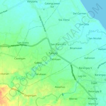
Nom : Carte topographique Talisay, altitude, relief.
Lieu : Talisay, Camarines Norte, Bicol Region, 4602, Philippines (14.09496 122.88373 14.17496 122.96373)
Altitude moyenne : 10 m
Altitude minimum : 0 m
Altitude maximum : 36 m
Faire un don
Équipez-vous pour votre prochaine aventure :
En tant que Partenaire Amazon, ce site perçoit une commission sur les achats éligibles sans surcoût pour vous.
Autres cartes topographiques
Cliquez sur une carte pour visualiser sa topographie, son altitude et son relief.
Daet
Daet is located in the southeastern part of Camarines Norte. It is bounded in the east by the town of Mercedes; in the south by the municipality of Basud; in southwest by San Lorenzo Ruiz town; in the north by Pacific Ocean; in the west by San Vicente and northwest by Talisay. The provincial capital covers a…
Altitude moyenne : 6 m
Faire un don
Équipez-vous pour votre prochaine aventure :
En tant que Partenaire Amazon, ce site perçoit une commission sur les achats éligibles sans surcoût pour vous.
Faire un don
Équipez-vous pour votre prochaine aventure :
En tant que Partenaire Amazon, ce site perçoit une commission sur les achats éligibles sans surcoût pour vous.
Daet
Daet is located in the southeastern part of Camarines Norte. It is bounded in the east by the town of Mercedes; in the south by the municipality of Basud; in southwest by San Lorenzo Ruiz town; in the north by Pacific Ocean; in the west by San Vicente and northwest by Talisay. The provincial capital covers a…
Altitude moyenne : 6 m
Faire un don
Équipez-vous pour votre prochaine aventure :
En tant que Partenaire Amazon, ce site perçoit une commission sur les achats éligibles sans surcoût pour vous.
Daet
Daet is located in the southeastern part of Camarines Norte. It is bounded in the east by the town of Mercedes; in the south by the municipality of Basud; in southwest by San Lorenzo Ruiz town; in the north by Pacific Ocean; in the west by San Vicente and northwest by Talisay. The provincial capital covers a…
Altitude moyenne : 6 m