
Carte topographique Tuftonboro
Carte interactive
Cliquez sur la carte pour afficher l’altitude.
Tuftonboro
According to the United States Census Bureau, the town has a total area of 50.0 square miles (129 km2), of which 41.0 square miles (106 km2) is land and 9.0 square miles (23 km2) is water, comprising 18.07% of the town. Tuftonboro is drained by the Melvin River and Beech River. Mirror Lake is in the south, and Dan Hole Pond is in the north. The highest point in Tuftonboro is the south peak of Mount Shaw, elevation 2,930 feet (890 m) above sea level, on the town's northwest boundary.
À propos de cette carte
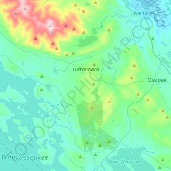
Nom : Carte topographique Tuftonboro, altitude, relief.
Lieu : Tuftonboro, Carroll County, New Hampshire, United States (43.58837 -71.34113 43.77041 -71.18618)
Altitude moyenne : 256 m
Altitude minimum : 121 m
Altitude maximum : 896 m