
Faire un don
Équipez-vous pour votre prochaine aventure :
En tant que Partenaire Amazon, ce site perçoit une commission sur les achats éligibles sans surcoût pour vous.
Carte topographique Legau
Cliquez sur la carte pour afficher l’altitude.
Faire un don
Équipez-vous pour votre prochaine aventure :
En tant que Partenaire Amazon, ce site perçoit une commission sur les achats éligibles sans surcoût pour vous.
À propos de cette carte
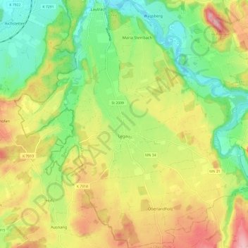
Nom : Carte topographique Legau, altitude, relief.
Altitude moyenne : 674 m
Altitude minimum : 605 m
Altitude maximum : 761 m
Faire un don
Équipez-vous pour votre prochaine aventure :
En tant que Partenaire Amazon, ce site perçoit une commission sur les achats éligibles sans surcoût pour vous.
Autres cartes topographiques
Cliquez sur une carte pour visualiser sa topographie, son altitude et son relief.
Bollenmühle
Deutschland > Bayern > Landkreis Unterallgäu > Ottobeuren > Ollarzried
Altitude moyenne : 767 m
Herbisried
Deutschland > Bayern > Landkreis Unterallgäu > Bad Grönenbach
Herbisried liegt in Oberschwaben in der Donau-Iller-Region, etwa drei Kilometer südlich von Bad Grönenbach, auf einer Höhe von 769 m ü. NN. An Herbisried grenzen im Uhrzeigersinn, im Norden beginnend, der Markt Bad Grönenbach, die Weiler Kornhofen, Hueb, Gmeinschwenden, Sommersberg und Greit. Mit Ausnahme…
Altitude moyenne : 731 m
Faire un don
Équipez-vous pour votre prochaine aventure :
En tant que Partenaire Amazon, ce site perçoit une commission sur les achats éligibles sans surcoût pour vous.
Faire un don
Équipez-vous pour votre prochaine aventure :
En tant que Partenaire Amazon, ce site perçoit une commission sur les achats éligibles sans surcoût pour vous.
Stockheim
Deutschland > Bayern > Landkreis Unterallgäu > Bad Wörishofen > Stockheim
Altitude moyenne : 629 m
Faire un don
Équipez-vous pour votre prochaine aventure :
En tant que Partenaire Amazon, ce site perçoit une commission sur les achats éligibles sans surcoût pour vous.
Guggenberg
Deutschland > Bayern > Landkreis Unterallgäu > Ottobeuren
Ottobeuren | Bäuerle | Betzisried | Bibelsberg | Böglins | Boschach | Brüchlins | Bühl | Daßberg | Dennenberg | Eggisried | Eheim | Eheimer Mühle | Eldern | Fröhlins | Geislins | Guggenberg | Gumpratsried | Gut | Hahnenbühl | Haitzen | Halbersberg | Hessen | Höhe | Hofs | Kloster Wald | Langenberg |…
Altitude moyenne : 696 m
Halbersberg
Deutschland > Bayern > Landkreis Unterallgäu > Ottobeuren > Langenberg
Ottobeuren | Bäuerle | Betzisried | Bibelsberg | Böglins | Boschach | Brüchlins | Bühl | Daßberg | Dennenberg | Eggisried | Eheim | Eheimer Mühle | Eldern | Fröhlins | Geislins | Guggenberg | Gumpratsried | Gut | Hahnenbühl | Haitzen | Halbersberg | Hessen | Höhe | Hofs | Kloster Wald | Langenberg |…
Altitude moyenne : 692 m
Faire un don
Équipez-vous pour votre prochaine aventure :
En tant que Partenaire Amazon, ce site perçoit une commission sur les achats éligibles sans surcoût pour vous.
Faire un don
Équipez-vous pour votre prochaine aventure :
En tant que Partenaire Amazon, ce site perçoit une commission sur les achats éligibles sans surcoût pour vous.
Brüchlins
Deutschland > Bayern > Landkreis Unterallgäu > Ottobeuren
Ottobeuren | Bäuerle | Betzisried | Bibelsberg | Böglins | Boschach | Brüchlins | Bühl | Daßberg | Dennenberg | Eggisried | Eheim | Eheimer Mühle | Eldern | Fröhlins | Geislins | Guggenberg | Gumpratsried | Gut | Hahnenbühl | Haitzen | Halbersberg | Hessen | Höhe | Hofs | Kloster Wald | Langenberg |…
Altitude moyenne : 677 m
Faire un don
Équipez-vous pour votre prochaine aventure :
En tant que Partenaire Amazon, ce site perçoit une commission sur les achats éligibles sans surcoût pour vous.
Faire un don
Équipez-vous pour votre prochaine aventure :
En tant que Partenaire Amazon, ce site perçoit une commission sur les achats éligibles sans surcoût pour vous.
Gmeinschwenden
Deutschland > Bayern > Landkreis Unterallgäu > Bad Grönenbach
Das Dorf liegt etwa drei Kilometer südlich von Bad Grönenbach auf einer Höhe von 750 m ü. NN. Die Landkreisgrenze zwischen Unterallgäu und Oberallgäu verläuft unmittelbar südlich des Dorfes. Gmeinschwenden grenzt im Norden an das Dorf Herbisried, sowie im weiteren Verlauf im Uhrzeigersinn an die Weiler…
Altitude moyenne : 726 m
Faire un don
Équipez-vous pour votre prochaine aventure :
En tant que Partenaire Amazon, ce site perçoit une commission sur les achats éligibles sans surcoût pour vous.
Faire un don
Équipez-vous pour votre prochaine aventure :
En tant que Partenaire Amazon, ce site perçoit une commission sur les achats éligibles sans surcoût pour vous.
Schlingen
Deutschland > Bayern > Landkreis Unterallgäu > Bad Wörishofen
Das Pfarrdorf Schlingen liegt westlich der Wertach auf einer Höhe von 642 m ü. NHN, umfasst ein Gebiet von rund 13,37 Quadratkilometer und hatte im Dezember 2021 746 Einwohner.
Altitude moyenne : 645 m
Faire un don
Équipez-vous pour votre prochaine aventure :
En tant que Partenaire Amazon, ce site perçoit une commission sur les achats éligibles sans surcoût pour vous.
Dietratried
Deutschland > Bayern > Landkreis Unterallgäu
Das Kirchdorf Dietratried liegt drei Kilometer nordwestlich von Wolfertschwenden, auf einer Höhe von 651 m ü. NN.
Altitude moyenne : 680 m
Faire un don
Équipez-vous pour votre prochaine aventure :
En tant que Partenaire Amazon, ce site perçoit une commission sur les achats éligibles sans surcoût pour vous.
Griesthal
Deutschland > Bayern > Landkreis Unterallgäu > Markt Rettenbach > Griesthal
Altitude moyenne : 759 m
Faire un don
Équipez-vous pour votre prochaine aventure :
En tant que Partenaire Amazon, ce site perçoit une commission sur les achats éligibles sans surcoût pour vous.
Faire un don
Équipez-vous pour votre prochaine aventure :
En tant que Partenaire Amazon, ce site perçoit une commission sur les achats éligibles sans surcoût pour vous.