
Carte topographique Schwarzberghorn
Carte interactive
Cliquez sur la carte pour afficher l’altitude.
À propos de cette carte
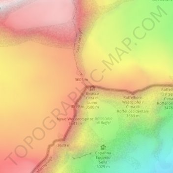
Nom : Carte topographique Schwarzberghorn, altitude, relief.
Lieu : Schwarzberghorn, Saas-Almagell, Visp, Vallese, 3905, Svizzera (45.99692 7.90865 45.99702 7.90875)
Altitude moyenne : 3 310 m
Altitude minimum : 2 433 m
Altitude maximum : 3 977 m
Autres cartes topographiques
Cliquez sur une carte pour visualiser sa topographie, son altitude et son relief.
Almagellerhorn
Svizzera > Vallese > Saas-Almagell
Almagellerhorn, Saas-Almagell, Visp, Vallese, 3905, Svizzera
Altitude moyenne : 2 703 m
Stausee Mattmark
Svizzera > Vallese > Saas-Almagell
Stausee Mattmark, Ze Seewjine, Saas-Almagell, Visp, Vallese, 3905, Svizzera
Altitude moyenne : 2 452 m
Strahlhorn
Svizzera > Vallese > Saas-Almagell
Strahlhorn, Saas-Almagell, Visp, Vallese, 3905, Svizzera
Altitude moyenne : 3 581 m
Stellihorn
Svizzera > Vallese > Saas-Almagell
Stellihorn, Saas-Almagell, Visp, Vallese, 3905, Svizzera
Altitude moyenne : 2 874 m