
Carte topographique Uchucarco
Carte interactive
Cliquez sur la carte pour afficher l’altitude.
À propos de cette carte
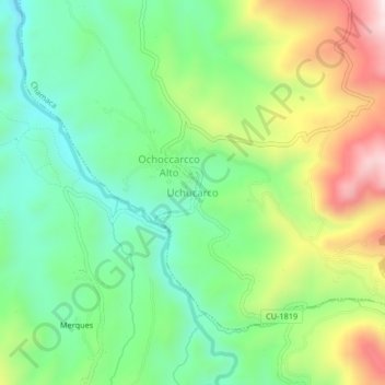
Nom : Carte topographique Uchucarco, altitude, relief.
Lieu : Uchucarco, Chamaca, Chumbivilcas, Cusco, Perú (-14.44302 -71.84552 -14.40302 -71.80552)
Altitude moyenne : 3 973 m
Altitude minimum : 3 779 m
Altitude maximum : 4 311 m
Autres cartes topographiques
Cliquez sur une carte pour visualiser sa topographie, son altitude et son relief.
Huninquiri
Huninquiri, Chamaca, Chumbivilcas, Cusco, Perú
Altitude moyenne : 3 979 m