
Carte topographique East River
Carte interactive
Cliquez sur la carte pour afficher l’altitude.
À propos de cette carte
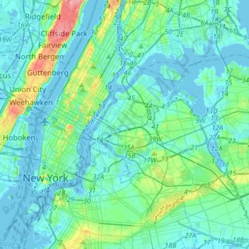
Nom : Carte topographique East River, altitude, relief.
Altitude moyenne : 15 m
Altitude minimum : -10 m
Altitude maximum : 100 m
Autres cartes topographiques
Cliquez sur une carte pour visualiser sa topographie, son altitude et son relief.
East Village
USA > New York > New York City
East Village, Manhattan, Manhattan Community Board 3, New York County, New York City, New York, USA
Altitude moyenne : 15 m
Meatpacking District
USA > New York > New York City
Meatpacking District, Manhattan, Manhattan Community Board 2, New York County, New York City, New York, 100014, USA
Altitude moyenne : 9 m
Governors Island
USA > New York > New York City
Governors Island, Manhattan Community Board 1, New York County, New York City, New York, USA
Altitude moyenne : 1 m
Chelsea
USA > New York > New York City
Chelsea, Manhattan, Manhattan Community Board 4, New York County, New York City, New York, USA
Altitude moyenne : 13 m
SoHo
USA > New York > New York City
SoHo, Manhattan, Manhattan Community Board 2, New York County, New York City, New York, 10012, USA
Altitude moyenne : 15 m
Barren Island
USA > New York > New York City
Barren Island, Kings County, New York City, New York, 11697, USA
Altitude moyenne : 16 m
Midtown East
USA > New York > New York City
Midtown East, Manhattan, Manhattan Community Board 5, New York County, New York City, New York, USA
Altitude moyenne : 22 m