
Carte topographique El Espino
Carte interactive
Cliquez sur la carte pour afficher l’altitude.
À propos de cette carte
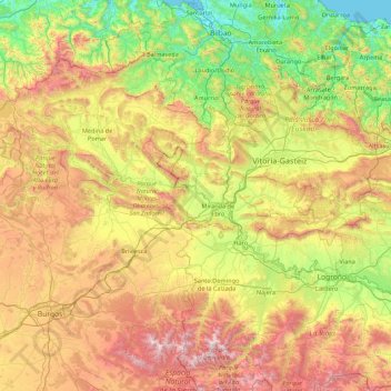
Nom : Carte topographique El Espino, altitude, relief.
Lieu : El Espino, Castile and León, 09219, Spain (42.08743 -3.68777 43.36743 -2.40777)
Altitude moyenne : 732 m
Altitude minimum : -1 m
Altitude maximum : 2 163 m
Autres cartes topographiques
Cliquez sur une carte pour visualiser sa topographie, son altitude et son relief.
Arévalo
Arévalo, Ávila, Castile and León, 05200, Spain
Altitude moyenne : 845 m
La Maya
Spain > Castile and León > La Maya
La Maya, Tierra de Alba, Salamanca, Castile and León, Spain
Altitude moyenne : 850 m
Burgos
Spain > Castile and León > Burgos
Burgos, Alfoz de Burgos, Burgos, Castile and León, Spain
Altitude moyenne : 907 m
Atua
Spain > Castile and León > Condado de Treviño
Atua, Condado de Treviño, Ebro, Burgos, Castile and León, Spain
Altitude moyenne : 629 m
Contreras
Spain > Castile and León > Contreras
Contreras, Sierra de la Demanda, Burgos, Castile and León, Spain
Altitude moyenne : 1 089 m
Pico Almanzor
Spain > Castile and León > Candeleda
Pico Almanzor, Candeleda, Comarca de Arenas de San Pedro, Ávila, Castile and León, Spain
Altitude moyenne : 2 159 m