
Carte topographique College Park
Carte interactive
Cliquez sur la carte pour afficher l’altitude.
À propos de cette carte
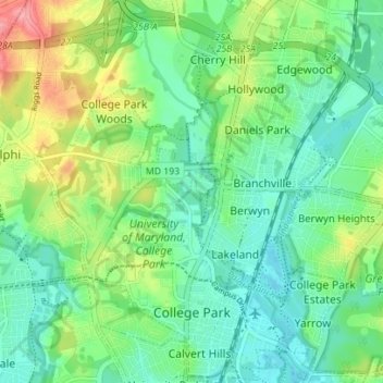
Nom : Carte topographique College Park, altitude, relief.
Altitude moyenne : 38 m
Altitude minimum : 10 m
Altitude maximum : 100 m
The Lakeland neighborhood was developed beginning in 1890 around the Baltimore and Ohio Railroad, whose Branchville and Calvert Road depots were located approximately one mile to the north and south, respectively. Lakeland was created by Edwin Newman, who improved the original 238 acres (0.96 km2) located to the west of the railroad. He also built a number of the original homes, a small town hall, and a general store. The area was originally envisioned as a resort-type community. However, due to the flood-prone, low-lying topography, the neighborhood became an area of African-American settlement. Around 1900, the Baltimore Gold Fish Company built five artificial lakes in the area to spawn goldfish and rarer species of fish. By 1903 Lakeland was an established African-American community with a school and two churches. Lakeland was central in a group of African American communities located along Route One through Prince Georges County. Lakeland High School opened in 1928 with funding from the Rosenwald Fund, the African American community and the county. Lakeland High served all African American students in the northern half of the county until 1950 when it was converted to a facility for lower grades. The community's first Rosenwald school was a new elementary which opened in 1925.
Autres cartes topographiques
Cliquez sur une carte pour visualiser sa topographie, son altitude et son relief.
Hyattsville
United States > Maryland > Prince George's County
Hyattsville, Prince George's County, Maryland, 20781, United States
Altitude moyenne : 61 m
North Brentwood
United States > Maryland > Prince George's County
North Brentwood, Prince George's County, Maryland, United States
Altitude moyenne : 15 m
Cottage City
United States > Maryland > Prince George's County
Cottage City, Prince George's County, Maryland, United States
Altitude moyenne : 17 m
Dinosaur Park
United States > Maryland > Prince George's County > South Laurel > Montpelier Forest
Dinosaur Park, Montpelier Forest, South Laurel, Prince George's County, Maryland, 20708, United States
Altitude moyenne : 67 m
Ammendale
United States > Maryland > Prince George's County > Konterra
Ammendale, Konterra, Prince George's County, Maryland, 20705, United States
Altitude moyenne : 56 m
North Keys
United States > Maryland > Prince George's County
North Keys, Prince George's County, Maryland, United States
Altitude moyenne : 43 m
Landover
United States > Maryland > Prince George's County > Landover
Landover, Prince George's County, Maryland, 20785, United States
Altitude moyenne : 38 m
Queenland
United States > Maryland > Prince George's County > Mellwood
Queenland, Mellwood, Prince George's County, Maryland, 20772, United States
Altitude moyenne : 42 m
Cedarville
United States > Maryland > Prince George's County
Cedarville, Prince George's County, Maryland, United States
Altitude moyenne : 63 m
Westphalia
United States > Maryland > Prince George's County
Westphalia, Prince George's County, Maryland, United States
Altitude moyenne : 62 m
Glassmanor
United States > Maryland > Prince George's County > Glassmanor
Glassmanor, Prince George's County, Maryland, United States
Altitude moyenne : 53 m
Colmar Manor
United States > Maryland > Prince George's County
Colmar Manor, Prince George's County, Maryland, United States
Altitude moyenne : 18 m
Lake Arbor
United States > Maryland > Prince George's County > Lake Arbor
Lake Arbor, Prince George's County, Maryland, United States
Altitude moyenne : 46 m
Hyattsville
United States > Maryland > Prince George's County
Hyattsville, Prince George's County, Maryland, 20782, United States
Altitude moyenne : 24 m
Landover Hills
United States > Maryland > Prince George's County
Landover Hills, Prince George's County, Maryland, United States
Altitude moyenne : 41 m
Capitol Heights
United States > Maryland > Prince George's County
Capitol Heights, Prince George's County, Maryland, United States
Altitude moyenne : 64 m
Fort Washington
United States > Maryland > Prince George's County > Fort Washington
Fort Washington, Prince George's County, Maryland, United States
Altitude moyenne : 29 m
Phelps Corner
United States > Maryland > Prince George's County > Oxon Hill
Phelps Corner, Oxon Hill, Prince George's County, Maryland, 20745, United States
Altitude moyenne : 58 m
Clinton
United States > Maryland > Prince George's County
Clinton, Prince George's County, Maryland, 20735, United States
Altitude moyenne : 64 m
Upper Marlboro
United States > Maryland > Prince George's County
Upper Marlboro, Prince George's County, Maryland, United States
Altitude moyenne : 22 m
Overbrook
United States > Maryland > Prince George's County > Bowie
Overbrook, Bowie, Prince George's County, Maryland, 20715, United States
Altitude moyenne : 32 m
Glenn Dale
United States > Maryland > Prince George's County > Glenn Dale
Glenn Dale, Prince George's County, Maryland, United States
Altitude moyenne : 52 m
District Heights
United States > Maryland > Prince George's County > District Heights
District Heights, Prince George's County, Maryland, 20747, United States
Altitude moyenne : 77 m
Bowie
United States > Maryland > Prince George's County > Bowie
Bowie, Prince George's County, Maryland, United States
Altitude moyenne : 38 m
Adelphi
United States > Maryland > Prince George's County > Adelphi
Adelphi, Prince George's County, Maryland, United States
Altitude moyenne : 56 m
Mount Rainier
United States > Maryland > Prince George's County
Mount Rainier, Prince George's County, Maryland, 20712, United States
Altitude moyenne : 20 m
Laurel
United States > Maryland > Prince George's County
Laurel, Prince George's County, Maryland, 20707, United States
Altitude moyenne : 73 m
Edmonston
United States > Maryland > Prince George's County
Edmonston, Prince George's County, Maryland, 20781, United States
Altitude moyenne : 21 m
Riverdale Park
United States > Maryland > Prince George's County
Riverdale Park, Prince George's County, Maryland, United States
Altitude moyenne : 23 m