
Carte topographique Stonyford
Carte interactive
Cliquez sur la carte pour afficher l’altitude.
À propos de cette carte
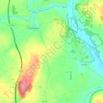
Nom : Carte topographique Stonyford, altitude, relief.
Altitude moyenne : 64 m
Altitude minimum : 16 m
Altitude maximum : 154 m
Autres cartes topographiques
Cliquez sur une carte pour visualiser sa topographie, son altitude et son relief.
The Municipal District of Callan — Thomastown
The Municipal District of Callan — Thomastown, County Kilkenny, Leinster, Ireland
Altitude moyenne : 100 m
Killeens
Killeens, Coolhill, The Municipal District of Callan — Thomastown, County Kilkenny, Leinster, Ireland
Altitude moyenne : 63 m
Urlingford
Urlingford, The Municipal District of Castlecomer, County Kilkenny, Leinster, Ireland
Altitude moyenne : 125 m
Westmoreland
Westmoreland, Aghaviller, The Municipal District of Callan — Thomastown, County Kilkenny, Leinster, Ireland
Altitude moyenne : 134 m
Sheastown
Sheastown, Outrath, The Municipal District of Callan — Thomastown, County Kilkenny, Leinster, Ireland
Altitude moyenne : 57 m
Kilkenny
Kilkenny, County Kilkenny, Leinster, Ireland
Altitude moyenne : 62 m