
Carte topographique Rohrbachstein
Carte interactive
Cliquez sur la carte pour afficher l’altitude.
À propos de cette carte
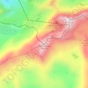
Nom : Carte topographique Rohrbachstein, altitude, relief.
Lieu : Rohrbachstein, Ayent, Hérens, Vallese, 1966, Svizzera (46.37637 7.46209 46.37647 7.46219)
Altitude moyenne : 2 603 m
Altitude minimum : 2 209 m
Altitude maximum : 2 940 m
Autres cartes topographiques
Cliquez sur une carte pour visualiser sa topographie, son altitude et son relief.
Schnidehorn
Schnidehorn, Ayent, Hérens, Vallese, 1966, Svizzera
Altitude moyenne : 2 566 m