
Carte topographique Llucmajor
Carte interactive
Cliquez sur la carte pour afficher l’altitude.
À propos de cette carte
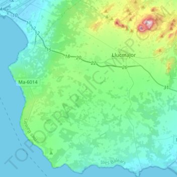
Nom : Carte topographique Llucmajor, altitude, relief.
Lieu : Llucmajor, Migjorn, Balearic Islands, Spain (39.35228 2.72187 39.55191 2.97645)
Altitude moyenne : 89 m
Altitude minimum : -2 m
Altitude maximum : 541 m
Autres cartes topographiques
Cliquez sur une carte pour visualiser sa topographie, son altitude et son relief.
Cala d'Or
Spain > Balearic Islands > Migjorn > Santanyí
Cala d'Or, Santanyí, Migjorn, Balearic Islands, 07660, Spain
Altitude moyenne : 17 m