
Carte topographique Dr Ruth Segomotsi Mompati District Municipality
Carte interactive
Cliquez sur la carte pour afficher l’altitude.
À propos de cette carte
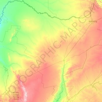
Nom : Carte topographique Dr Ruth Segomotsi Mompati District Municipality, altitude, relief.
Altitude moyenne : 1 234 m
Altitude minimum : 976 m
Altitude maximum : 1 854 m
Autres cartes topographiques
Cliquez sur une carte pour visualiser sa topographie, son altitude et son relief.
Rustenburg Local Municipality
RSA > North West > Rustenburg Local Municipality
Rustenburg Local Municipality, Bojanala Platinum District Municipality, North West, 0322, RSA
Altitude moyenne : 1 287 m
Brits
RSA > North West > Brits
Brits, Bojanala Platinum District Municipality, North West, 0250, RSA
Altitude moyenne : 1 120 m
Tlokwe Ward 2
RSA > North West > Tlokwe Local Municipality
Tlokwe Ward 2, Tlokwe Local Municipality, Dr Kenneth Kaunda District Municipality, North West, 2191, RSA
Altitude moyenne : 1 426 m
Brooksby
RSA > North West > Brooksby
Brooksby, Ngaka Modiri Molema District Municipality, North West, RSA
Altitude moyenne : 1 377 m