
Carte topographique Jayapura
Carte interactive
Cliquez sur la carte pour afficher l’altitude.
À propos de cette carte
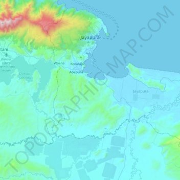
Nom : Carte topographique Jayapura, altitude, relief.
Lieu : Jayapura, Papua, Western New Guinea, Indonesia (-2.83925 140.60278 -2.47371 141.00000)
Altitude moyenne : 161 m
Altitude minimum : 0 m
Altitude maximum : 1 955 m
The topography of Jayapura varies from valleys to hills, plateaus, and mountains up to 700 metres (2,300 ft) above sea level. Jayapura overlooks the Yos Sudarso Bay. Jayapura is about 94,000 hectares (230,000 acres) in area, and is divided into five districts. Around 30% of the area is inhabited, with the remainder consisting of a rough terrain, swamps, and protected forest.
Autres cartes topographiques
Cliquez sur une carte pour visualiser sa topographie, son altitude et son relief.
Pulau Yapen
Indonesia > Papua > Yapen Islands Regency
Pulau Yapen, Yapen Islands Regency, Papua, 98211, Indonesia
Altitude moyenne : 39 m
Itlay Hisage
Indonesia > Papua > Jayawijaya
Itlay Hisage, Jayawijaya, Papua, Indonesia
Altitude moyenne : 2 943 m
Sungai Mamberamo
Sungai Mamberamo, Mamberamo Raya, Papua, Indonesia
Altitude moyenne : 3 m
Maoke Mountains
Maoke Mountains, Trikora District, Jayawijaya, Papua, Indonesia
Altitude moyenne : 2 858 m
Undundi-Wandandi
Undundi-Wandandi, Paniai, Papua, Indonesia
Altitude moyenne : 3 185 m