
Carte topographique Yavapai County
Carte interactive
Cliquez sur la carte pour afficher l’altitude.
À propos de cette carte
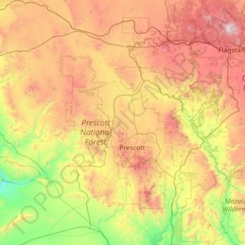
Nom : Carte topographique Yavapai County, altitude, relief.
Lieu : Yavapai County, Arizona, United States of America (33.88216 -113.33448 35.53065 -111.46127)
Altitude moyenne : 1 433 m
Altitude minimum : 345 m
Altitude maximum : 3 757 m
The county's topography makes a dramatic transition from the lower Sonoran Desert to the south to the heights of the Coconino Plateau to the north, and the Mogollon Rim to the east. The highest point above sea level (MSL) in Yavapai County is Mount Union at an elevation of 7,979 ft (2,432 m) and the lowest is Agua Fria River drainage, now under Lake Pleasant.
Autres cartes topographiques
Cliquez sur une carte pour visualiser sa topographie, son altitude et son relief.
Maricopa County
United States of America > Arizona
Maricopa County, Arizona, United States of America
Altitude moyenne : 549 m
Darling
United States of America > Arizona > Winona
Darling, Winona, Coconino County, Arizona, United States of America
Altitude moyenne : 1 916 m
Pima County
United States of America > Arizona
Pima County, Arizona, United States of America
Altitude moyenne : 807 m