
Carte topographique The Park at Haleland Park
Carte interactive
Cliquez sur la carte pour afficher l’altitude.
À propos de cette carte
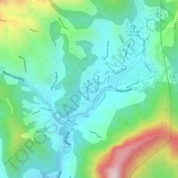
Nom : Carte topographique The Park at Haleland Park, altitude, relief.
Lieu : The Park at Haleland Park, Diego Martin, Trinidad and Tobago (10.71261 -61.50851 10.71384 -61.50774)
Altitude moyenne : 200 m
Altitude minimum : 53 m
Altitude maximum : 547 m
Autres cartes topographiques
Cliquez sur une carte pour visualiser sa topographie, son altitude et son relief.
Point Cumana
Trinidad and Tobago > Diego Martin
Point Cumana, Diego Martin, 110712, Trinidad and Tobago
Altitude moyenne : 70 m
Chacachacare
Trinidad and Tobago > Diego Martin > Chacachacare Island
Chacachacare, Chacachacare Island, Diego Martin, Trinidad and Tobago
Altitude moyenne : 18 m
Maraval River
Trinidad and Tobago > Diego Martin > Maraval
Maraval River, Maraval, Diego Martin, 190130, Trinidad and Tobago
Altitude moyenne : 49 m
Diego Martin
Trinidad and Tobago > Diego Martin
Diego Martin, Trinidad and Tobago
Altitude moyenne : 139 m