
Carte topographique Saratoga Springs
Carte interactive
Cliquez sur la carte pour afficher l’altitude.
À propos de cette carte
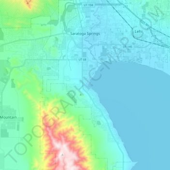
Nom : Carte topographique Saratoga Springs, altitude, relief.
Lieu : Saratoga Springs, Utah County, Utah, 84045, United States (40.26063 -111.97839 40.41673 -111.85576)
Altitude moyenne : 1 500 m
Altitude minimum : 1 365 m
Altitude maximum : 2 339 m
Saratoga Springs is a city in Utah County, Utah, United States. The elevation is 4,505 feet. It is part of the Provo–Orem, Utah Metropolitan Statistical Area. The city is a relatively new development along the northwestern shores of Utah Lake. It was incorporated on December 31, 1997 and has been growing rapidly since then. The population was 37,696 at the 2020 Census. Saratoga Springs became a city in 2001.
Autres cartes topographiques
Cliquez sur une carte pour visualiser sa topographie, son altitude et son relief.
Provo
United States > Utah > Utah County
Provo, Utah County, Utah, United States
Altitude moyenne : 1 728 m
Woodland Hills
United States > Utah > Utah County
Woodland Hills, Utah County, Utah, United States
Altitude moyenne : 1 812 m
Mount Timpanogos
United States > Utah > Utah County
Mount Timpanogos, Utah County, Utah, 84602, United States
Altitude moyenne : 3 139 m
Elk Ridge
United States > Utah > Utah County
Elk Ridge, Utah County, Utah, United States
Altitude moyenne : 1 698 m
Townsend
United States > Utah > Utah County > Genola
Townsend, Genola, Utah County, Utah, 84655, United States
Altitude moyenne : 1 438 m
Pleasant View
United States > Utah > Utah County > Provo
Pleasant View, Provo, Utah County, Utah, 84604, United States
Altitude moyenne : 1 446 m
Salem
United States > Utah > Utah County
Salem, Utah County, Utah, 84653, United States
Altitude moyenne : 1 473 m
Lehi
United States > Utah > Utah County
Lehi, Utah County, Utah, 84043, United States
Altitude moyenne : 1 465 m
Springville
United States > Utah > Utah County
Springville, Utah County, Utah, 84663, United States
Altitude moyenne : 1 566 m
Lone Peak
United States > Utah > Utah County
Lone Peak, Utah County, Utah, 84092, United States
Altitude moyenne : 3 013 m
Pleasant Grove
United States > Utah > Utah County
Pleasant Grove, Utah County, Utah, 84062, United States
Altitude moyenne : 1 578 m
Eagle Mountain
United States > Utah > Utah County
Eagle Mountain, Utah County, Utah, 84005, United States
Altitude moyenne : 1 589 m
Vineyard
United States > Utah > Utah County
Vineyard, Utah County, Utah, 84059, United States
Altitude moyenne : 1 382 m
Santaquin
United States > Utah > Utah County > Santaquin
Santaquin, Utah County, Utah, 84655, United States
Altitude moyenne : 1 701 m
Orem
United States > Utah > Utah County
Orem, Utah County, Utah, United States
Altitude moyenne : 1 457 m
Lindon
United States > Utah > Utah County
Lindon, Utah County, Utah, 84042, United States
Altitude moyenne : 1 537 m
Payson
United States > Utah > Utah County > Payson
Payson, Utah County, Utah, 84651, United States
Altitude moyenne : 1 473 m