
Carte topographique Ferghana
Carte interactive
Cliquez sur la carte pour afficher l’altitude.
À propos de cette carte
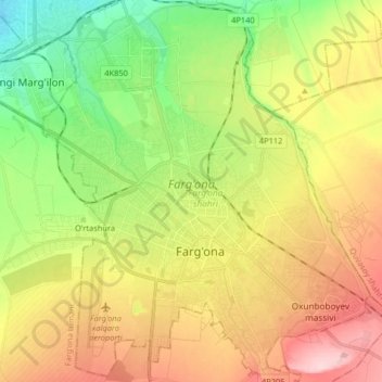
Nom : Carte topographique Ferghana, altitude, relief.
Lieu : Ferghana, Province de Ferghana, 150100, Ouzbékistan (40.33398 71.71937 40.45777 71.87386)
Altitude moyenne : 584 m
Altitude minimum : 494 m
Altitude maximum : 693 m
Autres cartes topographiques
Cliquez sur une carte pour visualiser sa topographie, son altitude et son relief.
Ravan
Ouzbékistan > Province de Ferghana > Soʻx tumani
Ravan, Soʻx tumani, Province de Ferghana, Ouzbékistan
Altitude moyenne : 1 160 m
Донбасс
Ouzbékistan > Province de Ferghana
Донбасс, Province de Ferghana, Ouzbékistan
Altitude moyenne : 448 m
Qorashoh
Ouzbékistan > Province de Ferghana > Quwa Tumani > Qorashoh
Qorashoh, Quwa Tumani, Province de Ferghana, 150818, Ouzbékistan
Altitude moyenne : 474 m
Marguilan
Ouzbékistan > Province de Ferghana > Toshloq Tumani
Marguilan, Toshloq Tumani, Province de Ferghana, 151100, Ouzbékistan
Altitude moyenne : 488 m