
Carte topographique Payson
Carte interactive
Cliquez sur la carte pour afficher l’altitude.
Payson
Located in northern Gila County at an elevation of 5,000 feet (1,500 m), the town has a total area of 19.5 square miles (51 km2). The Mogollon Rim, the southern boundary of the Colorado Plateau, lies to the north of Payson, with elevations exceeding 7,500 feet (2,300 m); there are many cold water lakes on top of the rim. They are stocked with fish by the Arizona Game and Fish Department.
À propos de cette carte
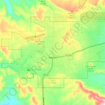
Nom : Carte topographique Payson, altitude, relief.
Lieu : Payson, Gila County, Arizona, 85072, United States (34.21706 -111.37054 34.27176 -111.27319)
Altitude moyenne : 1 522 m
Altitude minimum : 1 379 m
Altitude maximum : 1 725 m