
Faire un don
Équipez-vous pour votre prochaine aventure :
En tant que Partenaire Amazon, ce site perçoit une commission sur les achats éligibles sans surcoût pour vous.
Carte topographique Sugar Land
Cliquez sur la carte pour afficher l’altitude.
Faire un don
Équipez-vous pour votre prochaine aventure :
En tant que Partenaire Amazon, ce site perçoit une commission sur les achats éligibles sans surcoût pour vous.
Sugar Land
Sugar Land is located in northeast Fort Bend County, 20 miles (32 km) southwest of downtown Houston. It is bordered by Houston to the northeast, and by Stafford, Missouri City, and Meadows Place to the east. According to the United States Census Bureau, the city of Sugar Land has a total area of 42.9 square miles (111.1 km2), of which 40.5 square miles (104.8 km2) are land and 2.4 square miles (6.3 km2), or 5.7%, are covered by water. The elevation of most of the city is between 70 and 90 feet (21 and 27 m) above sea level. The elevation of Sugar Land Regional Airport (SGR) is 82 feet (25 m).
Faire un don
Équipez-vous pour votre prochaine aventure :
En tant que Partenaire Amazon, ce site perçoit une commission sur les achats éligibles sans surcoût pour vous.
À propos de cette carte
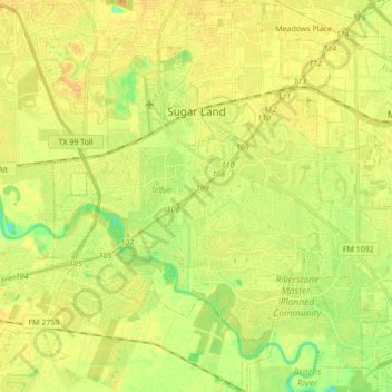
Nom : Carte topographique Sugar Land, altitude, relief.
Lieu : Sugar Land, Fort Bend County, Texas, United States (29.51252 -95.69811 29.66187 -95.58050)
Altitude moyenne : 24 m
Altitude minimum : 8 m
Altitude maximum : 33 m
Faire un don
Équipez-vous pour votre prochaine aventure :
En tant que Partenaire Amazon, ce site perçoit une commission sur les achats éligibles sans surcoût pour vous.