
Carte topographique North Bethesda
Carte interactive
Cliquez sur la carte pour afficher l’altitude.
À propos de cette carte
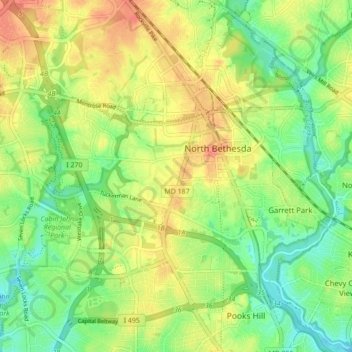
Nom : Carte topographique North Bethesda, altitude, relief.
Lieu : North Bethesda, Montgomery County, Maryland, United States (39.00704 -77.15518 39.07438 -77.08438)
Altitude moyenne : 98 m
Altitude minimum : 61 m
Altitude maximum : 147 m
Autres cartes topographiques
Cliquez sur une carte pour visualiser sa topographie, son altitude et son relief.
Randolph Hills
United States > Maryland > Montgomery County > North Bethesda
Randolph Hills, North Bethesda, Montgomery County, Maryland, 20896, United States
Altitude moyenne : 98 m