
Carte topographique Monroe
Carte interactive
Cliquez sur la carte pour afficher l’altitude.
À propos de cette carte
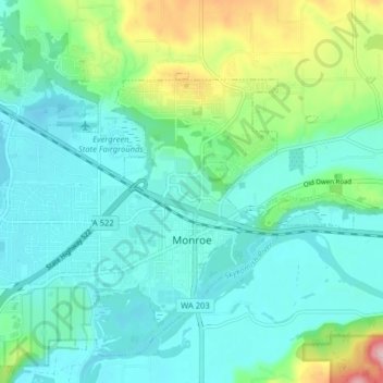
Nom : Carte topographique Monroe, altitude, relief.
Lieu : Monroe, Snohomish County, Washington, 98272, United States (47.83759 -122.01268 47.88630 -121.93306)
Altitude moyenne : 49 m
Altitude minimum : 3 m
Altitude maximum : 211 m
The city lies at the eastern end of the Snohomish River floodplain, with elevations that range from 40 to 210 feet (12 to 64 m). The south and east edges of the city along the Skykomish River are within a 100-year flood hazard zone and also include habitats for migratory birds and game animals. The residential neighborhoods of Monroe lie within the watersheds of French Creek and Woods Creek, which both drain into the Skykomish River before its confluence with the Snoqualmie and Snohomish rivers. The surrounding area includes hills and plateaus that were formed from glacial till and gravel deposits from the Skykomish River. Monroe also sits on a local fault line that produced a pair of minor earthquakes on July 12, 2019, that were felt as far as Seattle and Vancouver without causing damage.
Autres cartes topographiques
Cliquez sur une carte pour visualiser sa topographie, son altitude et son relief.
Three Lakes
United States > Washington > Snohomish County
Three Lakes, Snohomish County, Washington, United States
Altitude moyenne : 138 m
Hazel
United States > Washington > Snohomish County
Hazel, Snohomish County, Washington, United States
Altitude moyenne : 197 m
Arlington Heights
United States > Washington > Snohomish County
Arlington Heights, Snohomish County, Washington, United States
Altitude moyenne : 136 m
Everett
United States > Washington > Snohomish County
Everett, Snohomish County, Washington, United States
Altitude moyenne : 66 m
Mill Creek
United States > Washington > Snohomish County
Mill Creek, Snohomish County, Washington, United States
Altitude moyenne : 130 m
Northwest Snohomish
United States > Washington > Snohomish County > Snohomish
Northwest Snohomish, Snohomish, Snohomish County, Washington, 98291, United States
Altitude moyenne : 53 m
Lake Stevens
United States > Washington > Snohomish County
Lake Stevens, Snohomish County, Washington, 98258, United States
Altitude moyenne : 82 m
Edmonds
United States > Washington > Snohomish County
Edmonds, Snohomish County, Washington, United States
Altitude moyenne : 44 m
Mukilteo
United States > Washington > Snohomish County > Mukilteo
Mukilteo, Snohomish County, Washington, 98275, United States
Altitude moyenne : 89 m
Kennard Corner
United States > Washington > Snohomish County > North Creek
Kennard Corner, North Creek, Snohomish County, Washington, 98205, United States
Altitude moyenne : 92 m
Maltby
United States > Washington > Snohomish County > Maltby
Maltby, Snohomish County, Washington, United States
Altitude moyenne : 117 m