
Carte topographique Hetton
Carte interactive
Cliquez sur la carte pour afficher l’altitude.
À propos de cette carte
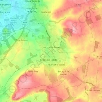
Nom : Carte topographique Hetton, altitude, relief.
Altitude moyenne : 106 m
Altitude minimum : 40 m
Altitude maximum : 162 m
Autres cartes topographiques
Cliquez sur une carte pour visualiser sa topographie, son altitude et son relief.
Easington Lane
United Kingdom > England > Sunderland
Easington Lane, Sunderland, North East, England, DH5 0LT, United Kingdom
Altitude moyenne : 117 m
Hetton-le-Hole
United Kingdom > England > Sunderland
Hetton-le-Hole, Sunderland, North East, England, DH5 9PE, United Kingdom
Altitude moyenne : 103 m