
Carte topographique Mogadishu
Carte interactive
Cliquez sur la carte pour afficher l’altitude.
À propos de cette carte
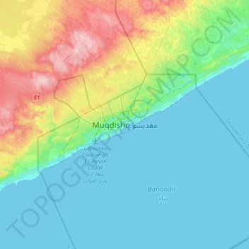
Nom : Carte topographique Mogadishu, altitude, relief.
Lieu : Mogadishu, Hamar Weyne District, Banaadir, BN 09010, Somalia (1.87493 45.18192 2.19493 45.50192)
Altitude moyenne : 43 m
Altitude minimum : 0 m
Altitude maximum : 181 m
Mogadishu is located in or near the tropical thorn woodland biome of the Holdridge global bioclimatic scheme. The mean temperature in the city year round is 27 °C (81 °F), with an average maximum of 30 °C (86 °F) and an average minimum of 24 °C (75 °F). Mean temperature readings per month vary by 3 °C (5.4 °F), corresponding with a hyperoceanic and subtype truly hyperoceanic continentality type. Precipitation per year averages 429.2 mm (16.9 in). There are 47 wet days annually, which are associated with a 12% annual daily probability of rainfall. The city has an average of 3,066 hours of sunshine per year, with 8.4 hours of sunlight per day. Mean daylight hours and minutes per day are 8 hours and 24 minutes. The percentage of possible sunshine is 70%. Average sun altitude at solar noon on the 21st day of the month is 75%.